Cafe nearby Maktal Coffee Bar
Indonesia
Cafe nearby Maktal Coffee Bar
Maktal Coffee Bar
Jalan Maktal, Cilinaya Indonesia
contacts phone
:
+62
Latitude:
-8.587748
, Longitude:
116.122341
read more
nearest Cafe
16 m
Cafe Maktal
Jalan Maktal, Cilinaya
Cafe
read more
150 m
Quick Chicken Pejanggik
Jalan Pejanggik No.104-108, Cakranegara Barat
Cafe
read more
248 m
Kafe Jembatan
Mataram Mall Lantai 3, Jalan Pejanggik, Cilinaya
Cafe
read more
268 m
Pappa Roti
Jalan Cilinaya No.1-3, Cilinaya
Cafe
read more
277 m
Oceanic
Mataram Mall, Jalan Pejanggik, Cilinaya
Cafe
read more
290 m
Begibuno
Mataram Mall Lantai 1 No. 24, JL. Pejangik, Cakranegara, Cilinaya
Cafe
read more
354 m
de'Cafe
Jalan Pejanggik, Gerung, Cakranegara Barat
Cafe
read more
496 m
Dapur Bakso Ns Rahim
Jalan Terusan Bung Hatta, Cilinaya
Cafe
read more
513 m
Mie Ayam Orange Bakso Selimut
Pejanggik
Cafe
read more
518 m
Axza Food Lombok
Jalan Bung Hatta, Cilinaya
Cafe
read more
552 m
Warhol Cafe
Jalan Swara Mahardika, Mataram Timur
Cafe
read more
565 m
Arik Pandawa , Cafe Tuak Iauu
West Cakranegara
Cafe
read more
587 m
samasisi
Jalan Caturwarga No.3, Mataram Timur
Cafe
read more
689 m
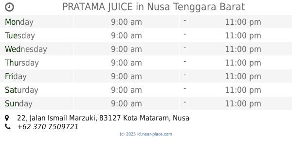
PRATAMA JUICE
Jalan Ismail Marzuki No.22, Cilinaya
Cafe
read more
707 m
dhelicia cafe
Mataram Timur
Cafe
read more
709 m
Kedai Kopi Tiang - Lombok Original Coffee
Cilinaya
Cafe
read more
790 m
KEBON Cafe & Resto
Jl. Caturwarga No.8B, Mataram Timur, Kecamatan Mataram, Mataram Timur
Cafe
read more
821 m
Angkringan Bung Karno
Jalan Bung Karno, Mataram Timur
Cafe
read more
885 m
Kios Bu Dek (Tri Warna - UD. Shanty)
Mataram Timur
Cafe
read more
890 m
Kedai Satay
Jalan Bung Karno, Mataram Timur
Cafe
read more
1.006 km
minuman segar chocolate pasco
Jalan Sriwijaya No.95, Pagesangan Timur
Cafe
read more
1.038 km
Sahban QORNER *KGCpoll*
Monjok Timur
Cafe
read more
1.071 km
Kdera Cafe & Resto
Jalan Pejanggik No.66, Pejanggik
Cafe
read more
1.079 km
Coco Beach Café
1 Robinson St., Pejanggik
Cafe
read more
1.096 km
Depot Rizqiyya
Jalan Sriwijaya, Cilinaya
Cafe
read more
📑
all categories
Accounting
Administrative area level 1
Administrative area level 2
Airport
Amusement park
Aquarium
Art gallery
Atm
Bakery
Bank
Bar
Beauty salon
Bicycle store
Book store
Bowling alley
Bus station
Cafe
Campground
Car dealer
Car rental
Car repair
Car wash
Casino
Cemetery
Church
City hall
Clothing store
Colloquial area
Convenience store
Courthouse
Dentist
Department store
Doctor
Electrician
Electronics store
Embassy
Finance
Fire station
Florist
Food
Funeral home
Furniture store
Gas station
General contractor
Grocery or supermarket
Gym
Hair care
Hardware store
Health
Hindu Temple
Home goods store
Hospital
Insurance agency
Intersection
Jewelry store
Laundry
Lawyer
Library
Liquor store
Local government office
Locality
Locksmith
Lodging
Meal delivery
Meal takeaway
Mosque
Movie rental
Movie theater
Moving company
Museum
Natural feature
Neighborhood
Night club
Painter
Park
Parking
Pet store
Pharmacy
Physiotherapist
Place of worship
Plumber
Point of interest
Police
Political
Post office
Premise
Real estate agency
Restaurant
Roofing contractor
Route
Rv park, camping
School
Shoe store
Shopping mall
Spa
Stadium
Storage
Store
Subpremise
Supermarket
Synagogue
Taxi stand
Train station
Transit station
Travel agency
University
Veterinary care
Zoo
administrative area level 3
administrative area level 4
administrative area level 5
sublocality level 1
↑