Cafe nearby kantin mak desi
Indonesia
Cafe nearby kantin mak desi
kantin mak desi
Jalan Nn Blok E1 No.12B, Rawa Buntu Indonesia
contacts phone
:
+62
Latitude:
-6.316142
, Longitude:
106.6837159
read more
nearest Cafe
189 m
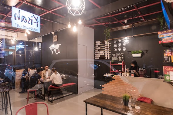
Kisah Board Game Cafe
Jalan Pusaka Kencana, Rawa Mekar Jaya
Cafe
read more
215 m
Warung Abah
Rawa Buntu
Cafe
read more
344 m
Warung bude darmi
Rawa Buntu
Cafe
read more
349 m
Diana napoleon
Rawa Buntu
Cafe
read more
355 m
Saung Kopi
no 68 15310, Jalan Nn No.8, RT.4/RW.1, Serpong
Cafe
read more
452 m
isoku iki
Rawa Buntu
Cafe
read more
457 m
Warung Akang
jln.kencana raya block G5 no 2.sektor 12.2.Rawa buntu serpong, Rawa Buntu
Cafe
read more
569 m
vespa caffe
Jalan Wana Kencana No.2, Ciater
Cafe
read more
627 m
Cafe Mommy Indah
Jalan Dahlia, Rawa Buntu
Cafe
read more
637 m
Cafe Saung Ceu Ita
Rawa Buntu
Cafe
read more
701 m
Cafe Aca
Jalan Stasiun Rawa Buntu, Rawa Buntu
Cafe
read more
790 m
Sosis Kargo Bu Dini
Rawa Buntu
Cafe
read more
826 m
NGOPI WAE
Ruko Serpong Park Blok BVA 2 No 57 Bsd Serpong, Rawa Buntu
Cafe
read more
833 m
Pempek Portal
Rawa Buntu, Serpong, Rawa Buntu
Cafe
read more
848 m
Warpeace Tayun
Jalan Taman Tanjung II, Rawa Buntu
Cafe
read more
855 m
Dapur Ngebul
Jl. Rawa Buntu Selatan No. 16, BSD City, Rawa Buntu
Cafe
read more
878 m
Frutylicious
Jalan Ciater Raya No.1, Rawa Mekar Jaya
Cafe
read more
889 m
warung kopdar Mamake
Unnamed Road, Ciater
Cafe
read more
930 m
D'Music Cafe
Rawa Mekar Jaya
Cafe
read more
973 m
Es Campur & Seblak Buyung
Rawa Mekar Jaya
Cafe
read more
981 m
Asinan Betawi Ibu Siti
Jalan Rawa Buntu Selatan, Rawa Buntu
Cafe
read more
988 m
Basecame Grabbike
Jalan Tanjung Blok J2 No.1, Rawa Buntu
Cafe
read more
1.183 km
es kelapa muda Bang Barol
Jalan Widya Kencana Blok T1 No.10, Ciater
Cafe
read more
1.184 km
Warung Pak Mugi
Rawa Mekar Jaya
Cafe
read more
1.188 km
Wan Suhe Revie Mimis
kp.ciater pinehill, Ciater
Cafe
read more
📑
all categories
Accounting
Administrative area level 1
Administrative area level 2
Airport
Amusement park
Aquarium
Art gallery
Atm
Bakery
Bank
Bar
Beauty salon
Bicycle store
Book store
Bowling alley
Bus station
Cafe
Campground
Car dealer
Car rental
Car repair
Car wash
Casino
Cemetery
Church
City hall
Clothing store
Colloquial area
Convenience store
Courthouse
Dentist
Department store
Doctor
Electrician
Electronics store
Embassy
Finance
Fire station
Florist
Food
Funeral home
Furniture store
Gas station
General contractor
Grocery or supermarket
Gym
Hair care
Hardware store
Health
Hindu Temple
Home goods store
Hospital
Insurance agency
Intersection
Jewelry store
Laundry
Lawyer
Library
Liquor store
Local government office
Locality
Locksmith
Lodging
Meal delivery
Meal takeaway
Mosque
Movie rental
Movie theater
Moving company
Museum
Natural feature
Neighborhood
Night club
Painter
Park
Parking
Pet store
Pharmacy
Physiotherapist
Place of worship
Plumber
Point of interest
Police
Political
Post office
Premise
Real estate agency
Restaurant
Roofing contractor
Route
Rv park, camping
School
Shoe store
Shopping mall
Spa
Stadium
Storage
Store
Subpremise
Supermarket
Synagogue
Taxi stand
Train station
Transit station
Travel agency
University
Veterinary care
Zoo
administrative area level 3
administrative area level 4
administrative area level 5
sublocality level 1
↑