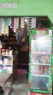
Cafe nearby InitehMilk
Indonesia
Cafe nearby InitehMilk
InitehMilk
Parkiran Ruko Permata cimanggis, Cimpaeun Indonesia
contacts phone
:
+62
Latitude:
-6.4456021
, Longitude:
106.8689064
read more
nearest Cafe
71 m
Warkop Ata
Jalan Tapos Raya Rt.01/04, Cimpaeun, Tapos, Cimpaeun
Cafe
read more
205 m
Toko Yogiva Yogurt & Fresh Milk
Jalan Raya Tapos, Cimpaeun
Cafe
read more
266 m
Susu Jahe
Jalan Raya Tapos No.26-49, Cimpaeun
Cafe
read more
374 m
Warkop Kaula
Jalan Cilangkap No.23, Cimpaeun
Cafe
read more
376 m
agen kelapa muda kurnia
Jalan Raya Tapos No.82, Cimpaeun
Cafe
read more
407 m
Waroeng Kite
Jalan Cilangkap No.29, Cimpaeun
Cafe
read more
421 m
Breakfast Station
Cimpaeun
Cafe
read more
469 m
Damkar Corner
Safir Permata Cianggis, Cimpaeun
Cafe
read more
650 m
SanPurNa Kafe
Jl. Tapos Raya No.46, Cimpaeun, Tapos, Cimpaeun
Cafe
read more
774 m
Cafe Fidiraya
Jalan Raya Tapos No.46, Cimpaeun
Cafe
read more
776 m
Kedai Tjiandjoer
16957 Jl. Tapos Raya Rt. 01 Rw. 03, Cimpaeun
Cafe
read more
779 m
Wadadaw Warkop
Jalan Banjaran Pucung, Cilangkap
Cafe
read more
806 m
Martabak Manis Telor L. A
Jalan Cilangkap No.34, Cilangkap
Cafe
read more
825 m
Bee Texas Indonesia
Jalan Cilangkap No.1d, Cilangkap
Cafe
read more
894 m
Warkop Mei-Mei
Jalan Banjaran Pucung, Cilangkap
Cafe
read more
908 m
Warkop Dewek
Cilangkap
Cafe
read more
916 m
Cafe Tika
Cimpaeun
Cafe
read more
949 m
Warung Empo
Cimpaeun
Cafe
read more
955 m
Warung Bude Sarnih
Cimpaeun
Cafe
read more
1.093 km
Kafe RIMact
depan kinasih resort, Cimpaeun
Cafe
read more
1.099 km
Dewa Angkringan Nyantai
Jalan Raya Tapos No.6, Cimpaeun
Cafe
read more
1.108 km
Avtha Grosir Powder Drink
Jalan Pesona Raya, Cilangkap
Cafe
read more
1.154 km
Storia Cafe
Cilangkap
Cafe
read more
1.227 km
Kiel Lg
Cilangkap
Cafe
read more
1.356 km
Warung kopi mak acih
Cilangkap
Cafe
read more
📑
all categories
Accounting
Administrative area level 1
Administrative area level 2
Airport
Amusement park
Aquarium
Art gallery
Atm
Bakery
Bank
Bar
Beauty salon
Bicycle store
Book store
Bowling alley
Bus station
Cafe
Campground
Car dealer
Car rental
Car repair
Car wash
Casino
Cemetery
Church
City hall
Clothing store
Colloquial area
Convenience store
Courthouse
Dentist
Department store
Doctor
Electrician
Electronics store
Embassy
Finance
Fire station
Florist
Food
Funeral home
Furniture store
Gas station
General contractor
Grocery or supermarket
Gym
Hair care
Hardware store
Health
Hindu Temple
Home goods store
Hospital
Insurance agency
Intersection
Jewelry store
Laundry
Lawyer
Library
Liquor store
Local government office
Locality
Locksmith
Lodging
Meal delivery
Meal takeaway
Mosque
Movie rental
Movie theater
Moving company
Museum
Natural feature
Neighborhood
Night club
Painter
Park
Parking
Pet store
Pharmacy
Physiotherapist
Place of worship
Plumber
Point of interest
Police
Political
Post office
Premise
Real estate agency
Restaurant
Roofing contractor
Route
Rv park, camping
School
Shoe store
Shopping mall
Spa
Stadium
Storage
Store
Subpremise
Supermarket
Synagogue
Taxi stand
Train station
Transit station
Travel agency
University
Veterinary care
Zoo
administrative area level 3
administrative area level 4
administrative area level 5
sublocality level 1
↑