Cafe nearby Gerobak Kopi Gayo
Coronavirus disease (COVID-19) Situation
confirmed cases
6829221
deaths
162063
Indonesia
Cafe nearby Gerobak Kopi Gayo
Gerobak Kopi Gayo
Jalan Amal Hamzah, Cinta Raja Indonesia
contacts phone
:
+62
Latitude:
0.5115012
, Longitude:
101.4522533
read more
nearest Cafe
95 m
MilkyHolic
Jalan Diponegoro, Simpang Empat
Cafe
read more
207 m
TEKO TERAS KOMPLEK
Cinta Raja
Cafe
read more
225 m
Sate Padang 72
Simpang Empat
Cafe
read more
236 m
MAXIMA ORIGIN BY PETERSELI
Jalan Pattimura, Cinta Raja
Cafe
read more
259 m
Grill Sausage And Tansu
Simpang Empat
Cafe
read more
556 m
Bofet Es Durian & Soto Padang
jln. Pepaya, Depan Plaza Citra, Jatirejo, City,, Jadirejo
Cafe
read more
586 m
Rich Kopi Plaza Citra Pekanbaru
Jalan Pepaya, Kampung Tengah
Cafe
read more
642 m
Cafe Bude Lali
Jalan Bintan Sudirman, Simpang Empat
Cafe
read more
657 m
WAROENG IJO
Jadirejo
Cafe
read more
700 m
Jus TATA
jl.satria, no 100A-100B, rejosari, komp, Pertokoan, Royal Platinum, Wonorejo
Cafe
read more
700 m
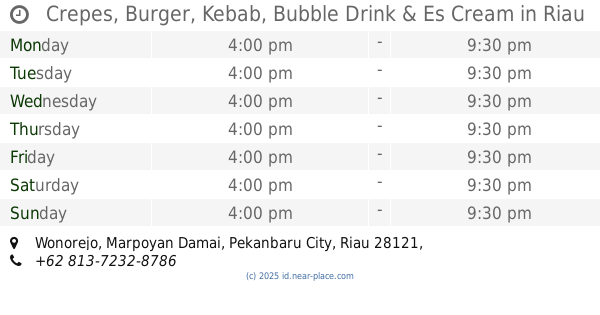
Crepes, Burger, Kebab, Bubble Drink & Es Cream
Wonorejo
Cafe
read more
706 m
Kedai Doloe
Jalan Pepaya No.52, Jadirejo
Cafe
read more
734 m
Kedai Kopi
Jalan Pepaya, Jadirejo
Cafe
read more
738 m
Rekopi
Jalan Pepaya No.38, Jadirejo
Cafe
read more
740 m
Wisata Kuliner
Jalan Jenderal Sudirman, Cinta Raja
Cafe
read more
749 m
Twist Potato Pekanbaru
Jalan Pepaya No.32, Jadirejo
Cafe
read more
755 m
IKHWAN BURGER & KEBAB
Jalan Pepaya, Jadirejo
Cafe
read more
781 m
Rumah Durian Radit
Jalan Jenderal Sudirman No.364, Wonorejo
Cafe
read more
912 m
Waroeng Kopi Pawon
Simpang Empat
Cafe
read more
927 m
Lokal Kopi
Jalan Pisang No.18, Wonorejo
Cafe
read more
946 m
Yuda Pratama
Jalan Nenas, Jadirejo
Cafe
read more
957 m
Kedai Kopi Pak Ngah Pw
Jl. Brigjend. Katamso, Bukit Raya
Cafe
read more
1.033 km
chocho sweet cafe..(sumur anker)
Jalan Pinang, Wonorejo
Cafe
read more
1.112 km
Cafe Sweety
Jalan Taskurun No.62B, Wonorejo
Cafe
read more
1.143 km
Mr. Kribourger
Jalan Belimbing, Wonorejo
Cafe
read more
📑
all categories
Accounting
Administrative area level 1
Administrative area level 2
Airport
Amusement park
Aquarium
Art gallery
Atm
Bakery
Bank
Bar
Beauty salon
Bicycle store
Book store
Bowling alley
Bus station
Cafe
Campground
Car dealer
Car rental
Car repair
Car wash
Casino
Cemetery
Church
City hall
Clothing store
Colloquial area
Convenience store
Courthouse
Dentist
Department store
Doctor
Electrician
Electronics store
Embassy
Finance
Fire station
Florist
Food
Funeral home
Furniture store
Gas station
General contractor
Grocery or supermarket
Gym
Hair care
Hardware store
Health
Hindu Temple
Home goods store
Hospital
Insurance agency
Intersection
Jewelry store
Laundry
Lawyer
Library
Liquor store
Local government office
Locality
Locksmith
Lodging
Meal delivery
Meal takeaway
Mosque
Movie rental
Movie theater
Moving company
Museum
Natural feature
Neighborhood
Night club
Painter
Park
Parking
Pet store
Pharmacy
Physiotherapist
Place of worship
Plumber
Point of interest
Police
Political
Post office
Premise
Real estate agency
Restaurant
Roofing contractor
Route
Rv park, camping
School
Shoe store
Shopping mall
Spa
Stadium
Storage
Store
Subpremise
Supermarket
Synagogue
Taxi stand
Train station
Transit station
Travel agency
University
Veterinary care
Zoo
administrative area level 3
administrative area level 4
administrative area level 5
sublocality level 1
↑