Cafe nearby Es Segar Manohara
Indonesia
Cafe nearby Es Segar Manohara
Es Segar Manohara
Jalan Brandweer, Pemagarsari Indonesien
contacts phone
:
+62
Latitude:
-6.4357932
, Longitude:
106.7289172
read more
nearest Cafe
169 m
Waroeng Si.ncan
Pemagarsari
Cafe
read more
434 m
Cafe Anak2 Fachri
Pemagarsari
Cafe
read more
473 m
Angkringan Kebun Mas Icam
Pemagarsari
Cafe
read more
600 m
Warung Tile
Jalan Mesjid Al-Irfan No.32, Pemagarsari
Cafe
read more
610 m
Warung Michael
Parung
Cafe
read more
624 m
Wedang Uwuh Om Tri
komp, Jalan Patal No.71, Gaga
Cafe
read more
641 m
Cafe Ww
Parung
Cafe
read more
658 m
Teras Parung
Jalan Raya Parung No.03, Parung
Cafe
read more
670 m
Warkop Sederhana
Jalan Raya Parung No.109, Parung
Cafe
read more
671 m
Cafe Ze
Pemagarsari
Cafe
read more
671 m
Cafe Ze
Indonesia
Cafe
read more
723 m
Numecca Cafe
Cafe
read more
848 m
cafe kiuk
Unnamed Road, Parung
Cafe
read more
879 m
@warungngetime
Parung
Cafe
read more
908 m
Warung kecil bu Nana
Parung
Cafe
read more
910 m
Roti Bakar 17 (Roti Bakar Masa Kini)
Jalan Raya Parung No.475, Parung
Cafe
read more
929 m
Seblak Pedas Bandung41
Jalan Masjid Al Islah No.48, Parung
Cafe
read more
951 m
Hisana Fried Chiken
Unnamed Road, Parung
Cafe
read more
1.005 km
WARUNG BURGER NAYUKI
Duren Seribu
Cafe
read more
1.024 km
Cafe Nangkring
Cafe
read more
1.051 km
cafe es sagwan
Jalan Raya Parung Ciseeng No.72, Parung
Cafe
read more
1.06 km
Warkop Tampomas
Jalan H. Mawi, RT 01 RW 04, Kp.Jati, Parung
Cafe
read more
1.061 km
#SalamJus
Jalan Haji Mawi No.56B, Waru
Cafe
read more
1.11 km
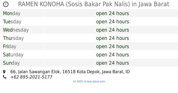
RAMEN KONOHA (Sosis Bakar Pak Nalis)
Jalan Sawangan Elok No.66, Duren Seribu
Cafe
read more
1.128 km
Kedai KOPI DOER
jln Haji Nawi, Jalan Raya Kemang Parung Bogor, Waru
Cafe
read more
📑
all categories
Accounting
Administrative area level 1
Administrative area level 2
Airport
Amusement park
Aquarium
Art gallery
Atm
Bakery
Bank
Bar
Beauty salon
Bicycle store
Book store
Bowling alley
Bus station
Cafe
Campground
Car dealer
Car rental
Car repair
Car wash
Casino
Cemetery
Church
City hall
Clothing store
Colloquial area
Convenience store
Courthouse
Dentist
Department store
Doctor
Electrician
Electronics store
Embassy
Finance
Fire station
Florist
Food
Funeral home
Furniture store
Gas station
General contractor
Grocery or supermarket
Gym
Hair care
Hardware store
Health
Hindu Temple
Home goods store
Hospital
Insurance agency
Intersection
Jewelry store
Laundry
Lawyer
Library
Liquor store
Local government office
Locality
Locksmith
Lodging
Meal delivery
Meal takeaway
Mosque
Movie rental
Movie theater
Moving company
Museum
Natural feature
Neighborhood
Night club
Painter
Park
Parking
Pet store
Pharmacy
Physiotherapist
Place of worship
Plumber
Point of interest
Police
Political
Post office
Premise
Real estate agency
Restaurant
Roofing contractor
Route
Rv park, camping
School
Shoe store
Shopping mall
Spa
Stadium
Storage
Store
Subpremise
Supermarket
Synagogue
Taxi stand
Train station
Transit station
Travel agency
University
Veterinary care
Zoo
administrative area level 3
administrative area level 4
administrative area level 5
sublocality level 1
↑