Cafe nearby Dapur Dua Jari
Indonesia
Cafe nearby Dapur Dua Jari
Dapur Dua Jari
Jalan Nuri Lrg II No.24H, Tanamodindi Indonesia
contacts phone
:
+62
Latitude:
-0.901421
, Longitude:
119.895411
read more
nearest Cafe
198 m
BOR'S BURGER
Jalan Nuri No.42c, Tanamodindi
Cafe
read more
216 m
cafe prasmanan
Tanamodindi
Cafe
read more
332 m
Kuliner Palu pisang goreng balaikota
Tanamodindi
Cafe
read more
388 m
Pisang Goreng Maleo
Jalan Maleo No.6, Tanamodindi
Cafe
read more
416 m
Cafe Milkyice
Jalan Balai Kota Timur No.No.19, Tanamodindi
Cafe
read more
512 m
Warkop Kpk Daeng Maman
Jalan Walikota, Entrop
Cafe
read more
512 m
Roti Comel
Jalan Walikota, Tanamodindi
Cafe
read more
547 m
Mas leo
Jalan Balai Kota Selatan, Tanamodindi
Cafe
read more
549 m
Mas leo siomay maknyus
Jalan Balai Kota Selatan, Tanamodindi
Cafe
read more
559 m
MMC STUDIO
Tanamodindi
Cafe
read more
624 m
CincauCay
Tanamodindi
Cafe
read more
628 m
Mrs. Cupi - Cumi Krispi
Jalan Balaikota, Tanamodindi
Cafe
read more
630 m
Mr. Creamy
Jalan Baruga, Tanamodindi
Cafe
read more
644 m
Kuliner palu pisang epe
Tanamodindi
Cafe
read more
653 m
Daebak Korean Cafe
Jalan Kakatua, Tanamodindi
Cafe
read more
759 m
Warkop Sikamali
Jalan Balai Kota Timur No.1, Tanamodindi
Cafe
read more
767 m
Kuliner palu Kaledo
North Lolu
Cafe
read more
784 m
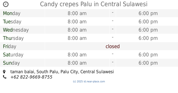
Candy crepes Palu
taman balai
Cafe
read more
794 m
Tastecoffee
Jalan Professor Muhammad Yamin, Lolu Utara
Cafe
read more
816 m
ROTI COMEL
Jalan Professor Muhammad Yamin, Lolu Utara
Cafe
read more
838 m
RM. Teratai
South Lolu
Cafe
read more
861 m
Monin Palu
North Lolu
Cafe
read more
974 m
Roemah El's
102-96, Jalan Tanjung Satu, Tatura Utara
Cafe
read more
1.113 km
Ahad - Net Internasional. PT
JL. Karoya, Kelurahan Paturah, Kecamatan Palu Barat, Tatura Utara
Cafe
read more
1.145 km
Warung Bang Buncit
Jalan Tanjung Manimbaya, Tatura Utara
Cafe
read more
📑
all categories
Accounting
Administrative area level 1
Administrative area level 2
Airport
Amusement park
Aquarium
Art gallery
Atm
Bakery
Bank
Bar
Beauty salon
Bicycle store
Book store
Bowling alley
Bus station
Cafe
Campground
Car dealer
Car rental
Car repair
Car wash
Casino
Cemetery
Church
City hall
Clothing store
Colloquial area
Convenience store
Courthouse
Dentist
Department store
Doctor
Electrician
Electronics store
Embassy
Finance
Fire station
Florist
Food
Funeral home
Furniture store
Gas station
General contractor
Grocery or supermarket
Gym
Hair care
Hardware store
Health
Hindu Temple
Home goods store
Hospital
Insurance agency
Intersection
Jewelry store
Laundry
Lawyer
Library
Liquor store
Local government office
Locality
Locksmith
Lodging
Meal delivery
Meal takeaway
Mosque
Movie rental
Movie theater
Moving company
Museum
Natural feature
Neighborhood
Night club
Painter
Park
Parking
Pet store
Pharmacy
Physiotherapist
Place of worship
Plumber
Point of interest
Police
Political
Post office
Premise
Real estate agency
Restaurant
Roofing contractor
Route
Rv park, camping
School
Shoe store
Shopping mall
Spa
Stadium
Storage
Store
Subpremise
Supermarket
Synagogue
Taxi stand
Train station
Transit station
Travel agency
University
Veterinary care
Zoo
administrative area level 3
administrative area level 4
administrative area level 5
sublocality level 1
↑