Cafe nearby CHICKEN SOGIL Taman Kirana
Indonesia
Cafe nearby CHICKEN SOGIL Taman Kirana
CHICKEN SOGIL Taman Kirana
Pasanggrahan Indonesia
contacts phone
:
+62
Latitude:
-6.2949841
, Longitude:
106.4176244
read more
nearest Cafe
108 m
Coffe Break
Pasanggrahan
Cafe
read more
327 m
Rm Manru
Jalan Belimbing, Pasanggrahan
Cafe
read more
689 m
cafe abah arsa
Unnamed Road, Cikareo
Cafe
read more
1.577 km
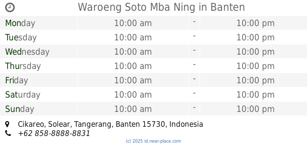
Waroeng Soto Mba Ning
Cikareo
Cafe
read more
1.629 km
Mie Ayam " PRJ "
Perumahan Taman Argo Subur Pesanggrahan, Pasanggrahan
Cafe
read more
1.691 km
Purwo LBF
Taman Argo Subur Blok S 3 no, 30, Pasanggrahan
Cafe
read more
2.553 km
Depot Uda Jamu&herbal
Jalan Raya Cisoka, Sukatani
Cafe
read more
2.553 km
Batagor Siomay Bandung
Jalan Raya Cisoka, Sukatani
Cafe
read more
2.625 km
artva studio musik
Jalan Raya Cisoka No.180, Sukatani
Cafe
read more
2.629 km
Laras Cake Shop
Jalan Cisoka Adiyasa Raya Kampung Lukun, RT.02/RW.1, Sukatani
Cafe
read more
2.719 km
Warkop Bu De Sur
Unnamed Road, Cikuya
Cafe
read more
2.747 km
Bakso Sms Mas Agus
Sukatani
Cafe
read more
2.798 km
warung bu rohim
Jalan Taman Adiyasa No.7, Kadu Agung
Cafe
read more
2.8 km
Warung Lulu
perumahan taman adiyasa blok N 20 no. 19 15730, Cikuya
Cafe
read more
2.982 km
Bakso & Mie Ayam Mang Anda
Unnamed Road, Sukatani
Cafe
read more
3.714 km
Warkop Fajar
Unnamed Road, Cikasungka
Cafe
read more
4.068 km
Toko Kue Cocik
Cileles
Cafe
read more
4.174 km
Warung Cungkil Faqih Rasul Destiano
Cikasungka
Cafe
read more
4.179 km
Kentang Crispy ALYA
perumahan kemuning permai C8 no, 5, Jeungjing
Cafe
read more
4.382 km
Cafe Purba
Unnamed Road, Jeungjing
Cafe
read more
4.474 km
Waroeng #Emejing Warbiyazah
Unnamed Road, Cikasungka
Cafe
read more
4.69 km
Milkshake Pemuda
Pasar Maja Blok AA No. 1, Jl. Raya Maja Koleang, Maja
Cafe
read more
5.389 km
Warkop Bu Dedeh
Jalan Terusan Stasiun, Singabraja
Cafe
read more
6.064 km
Warung kopi bu yuli
Pete
Cafe
read more
6.277 km
toko adih
Unnamed Road, Pete
Cafe
read more
📑
all categories
Accounting
Administrative area level 1
Administrative area level 2
Airport
Amusement park
Aquarium
Art gallery
Atm
Bakery
Bank
Bar
Beauty salon
Bicycle store
Book store
Bowling alley
Bus station
Cafe
Campground
Car dealer
Car rental
Car repair
Car wash
Casino
Cemetery
Church
City hall
Clothing store
Colloquial area
Convenience store
Courthouse
Dentist
Department store
Doctor
Electrician
Electronics store
Embassy
Finance
Fire station
Florist
Food
Funeral home
Furniture store
Gas station
General contractor
Grocery or supermarket
Gym
Hair care
Hardware store
Health
Hindu Temple
Home goods store
Hospital
Insurance agency
Intersection
Jewelry store
Laundry
Lawyer
Library
Liquor store
Local government office
Locality
Locksmith
Lodging
Meal delivery
Meal takeaway
Mosque
Movie rental
Movie theater
Moving company
Museum
Natural feature
Neighborhood
Night club
Painter
Park
Parking
Pet store
Pharmacy
Physiotherapist
Place of worship
Plumber
Point of interest
Police
Political
Post office
Premise
Real estate agency
Restaurant
Roofing contractor
Route
Rv park, camping
School
Shoe store
Shopping mall
Spa
Stadium
Storage
Store
Subpremise
Supermarket
Synagogue
Taxi stand
Train station
Transit station
Travel agency
University
Veterinary care
Zoo
administrative area level 3
administrative area level 4
administrative area level 5
sublocality level 1
↑