Cafe nearby Cafe Vera
Indonesia
Cafe nearby Cafe Vera
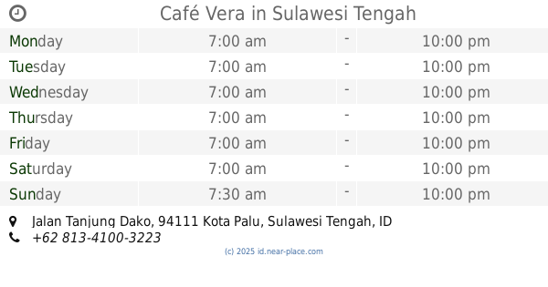
Cafe Vera
Jalan Maluku, 94111, Kota Palu, Sulawesi Tengah, ID Indonesia
contacts phone
:
+62
Latitude:
-0.9076491
, Longitude:
119.8748916
larger map & directions
read more
nearest Cafe
89 m
Coffe House
Jalan Tanjung Karang, Lolu Selatan
Cafe
read more
239 m
warkop AWENG MASOMBA
Jalan Tanjung Manimbaya No.135, Tatura Utara
Cafe
read more
290 m
kedai Es Belawa Choco Ghreen
Jalan Tanjung Karang, Lolu Selatan
Cafe
read more
439 m
Depot dan Warkop Mahkota ABE
Jalan Tanjung Karang, Lolu Selatan
Cafe
read more
585 m
Warkop Roemah Rakyat
South Lolu
Cafe
read more
626 m
Bengkel Bakso & Coffee
Jalan Anoa 1 No.46
Cafe
read more
650 m
Joinkopi Cafe
Jalan R.A. Kartini, Lolu Selatan
Cafe
read more
744 m
see you latte
North Lolu
Cafe
read more
765 m
Café Vera
Jalan Tanjung Dako, Lolu Selatan
Cafe
read more
782 m
Waffle Bar
Jalan Tanjung Satu, Tatura Utara
Cafe
read more
787 m
Kedai Terserah & Coffee Shop
Jalan Bali No.7, Lolu Selatan
Cafe
read more
797 m
Warkop Hanbae
Jalan Tanjung Dako, Lolu Selatan
Cafe
read more
811 m
Pizza Ummi Hafiz
Jalan Mesjid Raya No.334, Lolu Utara
Cafe
read more
817 m
Nasi Kuning Ningrat 5010
Lorong Kosgoro No.18A, Lolu Selatan
Cafe
read more
822 m
Warkop Aweng Mesjid Raya
Jalan Mesjid Raya, Lolu Utara
Cafe
read more
888 m
Andika
Palu
Cafe
read more
888 m
pantoloanCONFIRM
North Lolu
Cafe
read more
888 m
081354460911
North Lolu
Cafe
read more
898 m
Kue Bosa V
Jalan Gunung Bosa No.14, Lolu Utara
Cafe
read more
933 m
Dapoer_indo77
Jalan Mesjid Raya No.4, Lolu Utara
Cafe
read more
933 m
d' Zooba
Tatura Utara, Palu Selatan, Tatura Utara
Cafe
read more
962 m
Adinda Cakeri
Nunu
Cafe
read more
1000 m
Natuvu Net
Jalan R.A. Kartini, Palu Selatan, Lolu Selatan
Cafe
read more
1.003 km
JOIN COFFEE PALU
South Lolu
Cafe
read more
1.374 km
BaseCampCoffee
Jalan G. Sidole, Lolu Utara
Cafe
read more
📑
all categories
Accounting
Administrative area level 1
Administrative area level 2
Airport
Amusement park
Aquarium
Art gallery
Atm
Bakery
Bank
Bar
Beauty salon
Bicycle store
Book store
Bowling alley
Bus station
Cafe
Campground
Car dealer
Car rental
Car repair
Car wash
Casino
Cemetery
Church
City hall
Clothing store
Colloquial area
Convenience store
Courthouse
Dentist
Department store
Doctor
Electrician
Electronics store
Embassy
Finance
Fire station
Florist
Food
Funeral home
Furniture store
Gas station
General contractor
Grocery or supermarket
Gym
Hair care
Hardware store
Health
Hindu Temple
Home goods store
Hospital
Insurance agency
Intersection
Jewelry store
Laundry
Lawyer
Library
Liquor store
Local government office
Locality
Locksmith
Lodging
Meal delivery
Meal takeaway
Mosque
Movie rental
Movie theater
Moving company
Museum
Natural feature
Neighborhood
Night club
Painter
Park
Parking
Pet store
Pharmacy
Physiotherapist
Place of worship
Plumber
Point of interest
Police
Political
Post office
Premise
Real estate agency
Restaurant
Roofing contractor
Route
Rv park, camping
School
Shoe store
Shopping mall
Spa
Stadium
Storage
Store
Subpremise
Supermarket
Synagogue
Taxi stand
Train station
Transit station
Travel agency
University
Veterinary care
Zoo
administrative area level 3
administrative area level 4
administrative area level 5
sublocality level 1
↑