Cafe nearby Cafe Makassar
Indonesia
Cafe nearby Cafe Makassar
Cafe Makassar
Makassar, Selat Indonesia
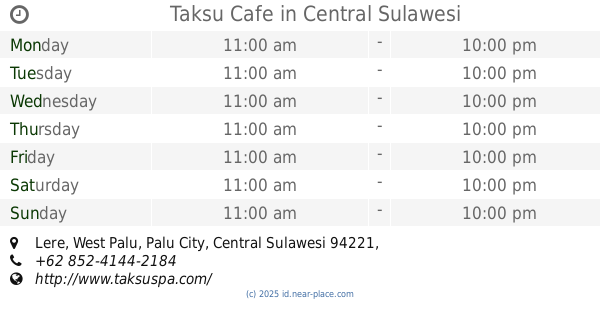
contacts phone
:
+62
Latitude:
-0.8734493
, Longitude:
119.8721842
read more
nearest Cafe
13 m
Cafe Citra Harapan
Jalan Munif Rahman, Talise
Cafe
read more
28 m
Cafe Bintang
Cafe
read more
38 m
Cafe Baim SPMA
Talise
Cafe
read more
176 m
Cafe Rafly
Jalan Penggaraman, Talise
Cafe
read more
196 m
Cafe Abang
Cafe
read more
220 m
Kafe Pink
Jalan Penggaraman, Talise
Cafe
read more
257 m
cafe rahman
Tim., Talise
Cafe
read more
860 m
Cafe Rizky Haris
Jalan Komodo No.16, Besusu Barat
Cafe
read more
864 m
Cafe Pojok
Jalan Komodo No.16, Besusu Barat
Cafe
read more
874 m
Cafe Kabelota
Jalan Komodo, Talise
Cafe
read more
914 m
Warkop Pinbuk
Tim, Talise
Cafe
read more
929 m
Kedai Halte
Tim., Talise
Cafe
read more
990 m
Warkop Ricky
Jalan Sam Ratulangi, Besusu Barat
Cafe
read more
1.084 km
Kedaiku-kedaimu
Jalan Kamboja, Talise
Cafe
read more
1.097 km
Cafe Takalar Dea
Jalan Komodo, Besusu Barat
Cafe
read more
1.14 km
Waroeng Ala Kipong
Jalan Gunung Tinombala, Talise
Cafe
read more
1.267 km
Bakso SOLO
Jalan Sam Ratulangi No.56, Besusu Barat
Cafe
read more
1.399 km
Ershi Box Coffee
Jalan Rajamoili, Besusu Barat
Cafe
read more
1.445 km
Es Durian Master
Jalan Raden Saleh No.25, Besusu Barat
Cafe
read more
1.449 km
kasubi yaku (singkong crunchy)
Jalan Doktor Suharso No.05, Besusu Barat
Cafe
read more
1.533 km
Cafe Lima (C5)
Unnamed Road, Talise
Cafe
read more
1.762 km
Art.fm Coffee & Food
Jalan Setia Budi, Besusu Tengah
Cafe
read more
1.859 km
Dum Dum Thai Drinks BNS S.Parman
Bumi Nyiur Swalayan (Foodcourt, Besusu Tengah
Cafe
read more
1.868 km
Lapangan Futsal Rajamoili 'n' Smile Cafe
Jalan Raden Saleh No.29a, Besusu Barat
Cafe
read more
2.179 km
Taksu Cafe
Lere
Cafe
read more
📑
all categories
Accounting
Administrative area level 1
Administrative area level 2
Airport
Amusement park
Aquarium
Art gallery
Atm
Bakery
Bank
Bar
Beauty salon
Bicycle store
Book store
Bowling alley
Bus station
Cafe
Campground
Car dealer
Car rental
Car repair
Car wash
Casino
Cemetery
Church
City hall
Clothing store
Colloquial area
Convenience store
Courthouse
Dentist
Department store
Doctor
Electrician
Electronics store
Embassy
Finance
Fire station
Florist
Food
Funeral home
Furniture store
Gas station
General contractor
Grocery or supermarket
Gym
Hair care
Hardware store
Health
Hindu Temple
Home goods store
Hospital
Insurance agency
Intersection
Jewelry store
Laundry
Lawyer
Library
Liquor store
Local government office
Locality
Locksmith
Lodging
Meal delivery
Meal takeaway
Mosque
Movie rental
Movie theater
Moving company
Museum
Natural feature
Neighborhood
Night club
Painter
Park
Parking
Pet store
Pharmacy
Physiotherapist
Place of worship
Plumber
Point of interest
Police
Political
Post office
Premise
Real estate agency
Restaurant
Roofing contractor
Route
Rv park, camping
School
Shoe store
Shopping mall
Spa
Stadium
Storage
Store
Subpremise
Supermarket
Synagogue
Taxi stand
Train station
Transit station
Travel agency
University
Veterinary care
Zoo
administrative area level 3
administrative area level 4
administrative area level 5
sublocality level 1
↑