Cafe nearby Bananaskripsi
Indonesia
Cafe nearby Bananaskripsi
Bananaskripsi
Jalan Kh. Tb. A. Khotib, 42117, Kota Serang, Banten, ID Indonesien
contacts phone
:
+62 853-1312-4500
Latitude:
-6.1210014
, Longitude:
106.1569854
larger map & directions
read more
nearest Cafe
261 m
Warung Es Dealicios
Jalan Ahmad Yani, Cipare
Cafe
read more
363 m
Warunk Upnormal - Serang
Jalan Veteran Blok Pegantungan Mesjid No. 12, Cipare, Serang
Cafe
read more
380 m
Caffe putri
Jalan Veteran No.24, Cipare
Cafe
read more
390 m
Cafe Mororene .jamer.
Cimuncang
Cafe
read more
410 m
Saung Hasya
Jln Jemd A Yani No, RT.001/RW.4, Cipare
Cafe
read more
434 m
Warung Kopi Benggala Teh Erni
Jalan Ustad Uzer, Kotabaru
Cafe
read more
443 m
Waroeng 52
Gang Penerangan, Cipare
Cafe
read more
535 m
Dabelyuw Kitchen
Cipare
Cafe
read more
551 m
Voc Coffee
Jalan Ki Masjong No.12, 4, Kotabaru
Cafe
read more
611 m
Baso Ceker Bella
Jalan Veteran No.94, Kotabaru
Cafe
read more
618 m
ALEXXA LOUNGE 'N KARAOKE
Jalan Veteran No.94, Kotabaru
Cafe
read more
666 m
Banana Nugget Sweet Sumurpecung
Cimuncang
Cafe
read more
673 m
Perangko Cafe
Jalan Veteran No.3, Kotabaru
Cafe
read more
739 m
Kedai Bilop
Jalan Maulana Yusuf No.24-25, Taman Sari, Cimuncang
Cafe
read more
750 m
dr-organics
Serang
Cafe
read more
760 m
Excelso Coffee Kota Serang
Jalan K.H. Abdul Hadi No.96a, Cipare
Cafe
read more
798 m
WarKop ACEH
Kotabaru
Cafe
read more
800 m
Juice Taman Sari
Jalan Sultan Agung Tirtayasa, Cimuncang
Cafe
read more
835 m
Kedai Ibu Eha
Jalan Sempu Kelapa Endep, Cipare
Cafe
read more
872 m
Kopdar SSFC Korwil Serang (Pusat)
Sumurpecung
Cafe
read more
947 m
spagetti & cake.
Jalan Raya Pandeglang No.56, Cipare
Cafe
read more
953 m
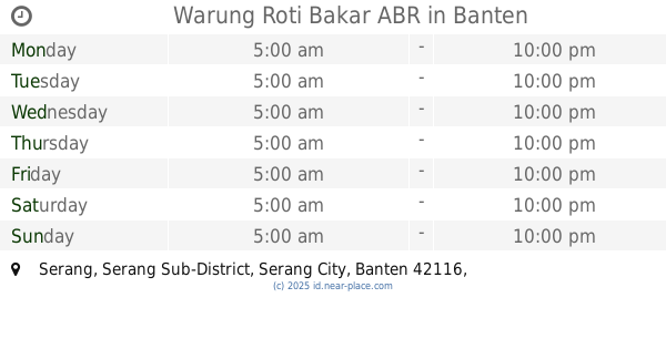
Warung Roti Bakar ABR
Serang
Cafe
read more
954 m
LAUTAN K5 "Ratunya Pinggir Laut"
Jalan Kyai Haji Abdul Latif, Sumurpecung
Cafe
read more
1.115 km
Viki Mini Cafe
Jalan Kolonel Tubagus Suwandi No.7, Serang
Cafe
read more
1.227 km
Base Camp GSS (Gojek Secang)
Jalan KH. Abdul Latief, Cimuncang
Cafe
read more
📑
all categories
Accounting
Administrative area level 1
Administrative area level 2
Airport
Amusement park
Aquarium
Art gallery
Atm
Bakery
Bank
Bar
Beauty salon
Bicycle store
Book store
Bowling alley
Bus station
Cafe
Campground
Car dealer
Car rental
Car repair
Car wash
Casino
Cemetery
Church
City hall
Clothing store
Colloquial area
Convenience store
Courthouse
Dentist
Department store
Doctor
Electrician
Electronics store
Embassy
Finance
Fire station
Florist
Food
Funeral home
Furniture store
Gas station
General contractor
Grocery or supermarket
Gym
Hair care
Hardware store
Health
Hindu Temple
Home goods store
Hospital
Insurance agency
Intersection
Jewelry store
Laundry
Lawyer
Library
Liquor store
Local government office
Locality
Locksmith
Lodging
Meal delivery
Meal takeaway
Mosque
Movie rental
Movie theater
Moving company
Museum
Natural feature
Neighborhood
Night club
Painter
Park
Parking
Pet store
Pharmacy
Physiotherapist
Place of worship
Plumber
Point of interest
Police
Political
Post office
Premise
Real estate agency
Restaurant
Roofing contractor
Route
Rv park, camping
School
Shoe store
Shopping mall
Spa
Stadium
Storage
Store
Subpremise
Supermarket
Synagogue
Taxi stand
Train station
Transit station
Travel agency
University
Veterinary care
Zoo
administrative area level 3
administrative area level 4
administrative area level 5
sublocality level 1
↑