Bus station nearby Studio Palem Kemang
Indonesia
Bus station nearby Studio Palem Kemang
Studio Palem Kemang
Bangka, Mampang Prapatan, South Jakarta City, Jakarta, Indonesien
contacts phone
:
+62
Latitude:
-6.25822
, Longitude:
106.823007
larger map & directions
read more
nearest Bus station
273 m
Musholla Arrohmah
Indonesia
Bus station
read more
564 m
Sarana Building
Indonesia
Bus station
read more
579 m
Imigrasi
RT.2/RW.1, Duren Tiga, Pancoran
Bus station
read more
586 m
Sumber Alam Laundry
Indonesia
Bus station
read more
599 m
Kantor Imigrasi
Indonesia
Bus station
read more
622 m
Rumah Makan Bersaudara
Indonesia
Bus station
read more
660 m
Posyandu Mawar 2
Indonesia
Bus station
read more
736 m
Alfamart Mampang Prapatan 2
Indonesia
Bus station
read more
782 m
Duren Tiga
Jalan Mampang Prapatan RT.1/RW.6, Tegal Parang
Bus station
read more
789 m
Halte Busway Duren Tiga (Arah Mampang)
Jalan Mampang Prapatan Raya No. 4-98, Tegal Parang, Mampang Prapatan
Bus station
read more
798 m
Tiki Drive Trhu Duren Tiga
Indonesia
Bus station
read more
860 m
PT. PLN Batu Bara
Indonesia
Bus station
read more
872 m
Warung Jati
RT.6/RW.3, Kalibata
Bus station
read more
873 m
Opposite AHS Handoyo
Indonesia
Bus station
read more
883 m
Wisma Asia Kalibata Tengah
Indonesia
Bus station
read more
895 m
Opposite Bidan Syamsiar M
Indonesia
Bus station
read more
908 m
Opposite Masjid Pomad
Indonesia
Bus station
read more
923 m
Halte Kemang
Jalan Kemang Selatan RT.9/RW.1, Bangka
Bus station
read more
967 m
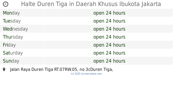
Halte Duren Tiga
Jalan Raya Duren Tiga RT.07RW.05, no 3cDuren Tiga
Bus station
read more
985 m
Opposite Khrisna Gallery
Indonesia
Bus station
read more
1.024 km
Center Pasar Minggu
Indonesia
Bus station
read more
1.028 km
Polsek Pancoran
Indonesia
Bus station
read more
1.029 km
Tunas Toyota Mampang
Indonesia
Bus station
read more
1.036 km
Polsek Pancoran,Jl.Warung Jati Barat
Indonesia
Bus station
read more
1.042 km
Halte Mampang 10
Indonesia
Bus station
read more
📑
all categories
Accounting
Administrative area level 1
Administrative area level 2
Airport
Amusement park
Aquarium
Art gallery
Atm
Bakery
Bank
Bar
Beauty salon
Bicycle store
Book store
Bowling alley
Bus station
Cafe
Campground
Car dealer
Car rental
Car repair
Car wash
Casino
Cemetery
Church
City hall
Clothing store
Colloquial area
Convenience store
Courthouse
Dentist
Department store
Doctor
Electrician
Electronics store
Embassy
Finance
Fire station
Florist
Food
Funeral home
Furniture store
Gas station
General contractor
Grocery or supermarket
Gym
Hair care
Hardware store
Health
Hindu Temple
Home goods store
Hospital
Insurance agency
Intersection
Jewelry store
Laundry
Lawyer
Library
Liquor store
Local government office
Locality
Locksmith
Lodging
Meal delivery
Meal takeaway
Mosque
Movie rental
Movie theater
Moving company
Museum
Natural feature
Neighborhood
Night club
Painter
Park
Parking
Pet store
Pharmacy
Physiotherapist
Place of worship
Plumber
Point of interest
Police
Political
Post office
Premise
Real estate agency
Restaurant
Roofing contractor
Route
Rv park, camping
School
Shoe store
Shopping mall
Spa
Stadium
Storage
Store
Subpremise
Supermarket
Synagogue
Taxi stand
Train station
Transit station
Travel agency
University
Veterinary care
Zoo
administrative area level 3
administrative area level 4
administrative area level 5
sublocality level 1
↑