Bus station nearby Onyx Spa & Aromatherapy
Indonesia
Bus station nearby Onyx Spa & Aromatherapy
Onyx Spa & Aromatherapy
Indonesia Indonesia
contacts phone
:
+62
Latitude:
-6.225858
, Longitude:
106.858325
read more
nearest Bus station
389 m
Indomaret Asem Baris 2
Indonesia
Bus station
read more
408 m
SMPN 115 Jakarta
Indonesia
Bus station
read more
500 m
Alfamidi
Indonesia
Bus station
read more
537 m
stasiun tebet raya
Jalan Tebet Raya, Tebet Timur
Bus station
read more
637 m
Raypavor Corner
Indonesia
Bus station
read more
679 m
TB Betawi
Indonesia
Bus station
read more
762 m
Halte Telkom
Halte Telkom, Jalan Kh. Abdullah Syafe'i, Tebet
Bus station
read more
778 m
Opposite RM Uda Denai
Indonesia
Bus station
read more
810 m
Mamink Daeng Tata
Indonesia
Bus station
read more
835 m
Stasiun Tebet - Dalam
Jalan KH. Abdullah Syafei No.37, Manggarai Selatan
Bus station
read more
931 m
Jl. Jatinegara Barat
RT.10/RW.1, Bidara Cina
Bus station
read more
939 m
Kampung Melayu
Bali Mester
Bus station
read more
944 m
Halte Kampung Melayu
studio myra,bassuki rahmat Jatinegara, Bali Mester, Jatinegara
Bus station
read more
951 m
Opposite PD Anugrah
Indonesia
Bus station
read more
978 m
Terminal Kampung Melayu
Indonesia
Bus station
read more
981 m
SD Santa Maria Fatima
Indonesia
Bus station
read more
982 m
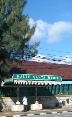
Halte Santa Maria
Jalan Jatinegara Barat RT.7/RW.1, Bidara Cina
Bus station
read more
989 m
Rama Indah Motors
Indonesia
Bus station
read more
991 m
Apotik Setia Senjaya
Indonesia
Bus station
read more
1.061 km
Alfamidi Otista
Indonesia
Bus station
read more
1.068 km
SMKN 32 Jakarta
Indonesia
Bus station
read more
1.073 km
Bidara Cina
Kp. Melayu Jatinegara, Gang Saabun, RT.5/RW.9, Kampung Melayu, Jatinegara
Bus station
read more
1.073 km
SMKN 32
Indonesia
Bus station
read more
1.074 km
Bidara Cina
RT.1/RW.3, Kampung Melayu, Jatinegara
Bus station
read more
1.205 km
SPBU Gas Station
Indonesia
Bus station
read more
📑
all categories
Accounting
Administrative area level 1
Administrative area level 2
Airport
Amusement park
Aquarium
Art gallery
Atm
Bakery
Bank
Bar
Beauty salon
Bicycle store
Book store
Bowling alley
Bus station
Cafe
Campground
Car dealer
Car rental
Car repair
Car wash
Casino
Cemetery
Church
City hall
Clothing store
Colloquial area
Convenience store
Courthouse
Dentist
Department store
Doctor
Electrician
Electronics store
Embassy
Finance
Fire station
Florist
Food
Funeral home
Furniture store
Gas station
General contractor
Grocery or supermarket
Gym
Hair care
Hardware store
Health
Hindu Temple
Home goods store
Hospital
Insurance agency
Intersection
Jewelry store
Laundry
Lawyer
Library
Liquor store
Local government office
Locality
Locksmith
Lodging
Meal delivery
Meal takeaway
Mosque
Movie rental
Movie theater
Moving company
Museum
Natural feature
Neighborhood
Night club
Painter
Park
Parking
Pet store
Pharmacy
Physiotherapist
Place of worship
Plumber
Point of interest
Police
Political
Post office
Premise
Real estate agency
Restaurant
Roofing contractor
Route
Rv park, camping
School
Shoe store
Shopping mall
Spa
Stadium
Storage
Store
Subpremise
Supermarket
Synagogue
Taxi stand
Train station
Transit station
Travel agency
University
Veterinary care
Zoo
administrative area level 3
administrative area level 4
administrative area level 5
sublocality level 1
↑