
closed
🕗 opening times
| Monday | - | |||||
| Tuesday | - | |||||
| Wednesday | - | |||||
| Thursday | - | |||||
| Friday | - | |||||
| Saturday | - | |||||
| Sunday | - | |||||
Jalan Pagelarang, 13890, Kota Jakarta Timur, Daerah Khusus Ibukota Jakarta, ID Indonesia
contacts phone: +62
larger map & directionsLatitude: -6.3027622, Longitude: 106.9147826


Young Cripano
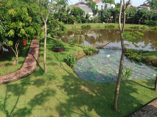
::Great place for jogging, light sport activity or just hang out with friends and family
Sarah Anggraheni
::This is great! Rafting in this river is about 5km long... Furthermore, your eyes would see the very pretty scenery along this river! It's so refreshing!
Aditya Saputro
::One of a few public park in Jakarta, many communities came here to have their routine gathering such as pet community, bicyclists community, and martial arts community. It also have parking field that can contain more than 10 cars + 50 motorcycles. Oh, i came here to come to my friend's wedding party, it can be a nice place to held it too..
Alfath Alfatir
::Nice Place for jogging and other sport activity especially on sunday... Its really crowded with people, street snack & Drinks every sunday... Sometimes there is event in this area almost every weekend...
lusanda fitria
::Nice place to take some pictures with clean environment and beautiful view, there is a jogging track too and good for bring kids. Tempatnya bagus utk foto, lingkungannya bersih dan pemandangannya indah. Ada jogging track juga dan aman utk membawa anak-anak