Supermarket nearby Toko Haji Edi
Indonesia
Supermarket nearby Toko Haji Edi
Toko Haji Edi
Jalan Desa, Karang Tengah Indonesia
contacts phone
:
+62
Latitude:
-6.5808966
, Longitude:
106.9231493
read more
nearest Supermarket
1.19 km
Toko Salsabila
Jalan Wangun Sari, Karangtengah
Supermarket
read more
1.592 km
Warung Iduy
Central Karang
Supermarket
read more
2.043 km
Toserba Ujung Curug
Unnamed Road, Karang Tengah
Supermarket
read more
2.893 km
aluminium cijayanti
Bojong Koneng
Supermarket
read more
3.465 km
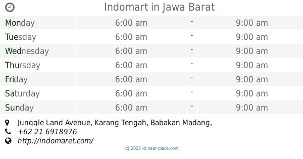
Indomart
Junggle Land Avenue, Karang Tengah
Supermarket
read more
3.56 km
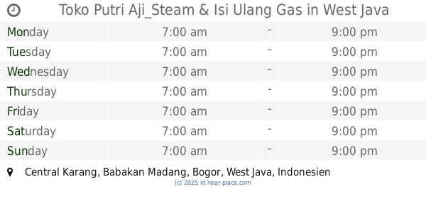
Toko Putri Aji_Steam & Isi Ulang Gas
Central Karang
Supermarket
read more
3.875 km
waroeng dalung
Bojong Koneng
Supermarket
read more
3.876 km
Roni Romelan
Bojong Koneng
Supermarket
read more
3.96 km
Indomaret Sentul Selatan 2
Jalan Gunung Pancar, Sumur Batu
Supermarket
read more
3.96 km
Indomaret Sentul Selatan 2
Jalan Raya Gunung Pancar, Sumur Batu
Supermarket
read more
4.025 km
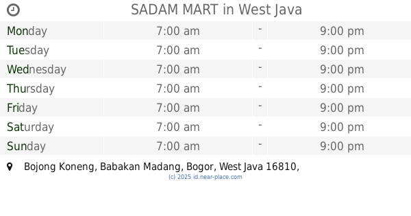
SADAM MART
Bojong Koneng
Supermarket
read more
4.042 km
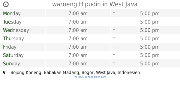
waroeng H.pudin
Bojong Koneng
Supermarket
read more
4.596 km
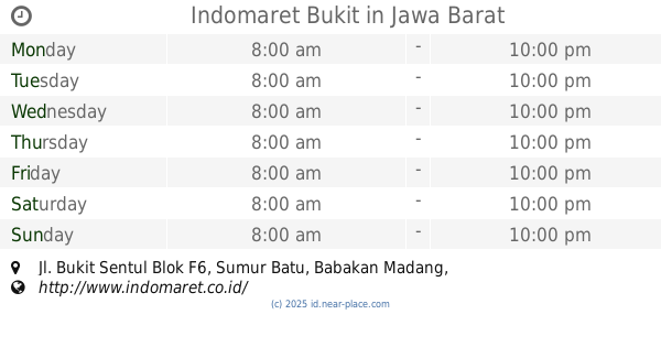
Indomaret Bukit
Jl. Bukit Sentul Blok F6, Sumur Batu, Babakan Madang, Sumur Batu
Supermarket
read more
4.864 km
Bilqis Cellular
Jalan Raya Gunung Pancar, Sumur Batu
Supermarket
read more
4.864 km
Bilqis Cellular
Jalan Gunung Pancar, Sumur Batu
Supermarket
read more
4.903 km
circle U
Unnamed Road, Bojong Koneng
Supermarket
read more
5.397 km
Toko Ibu Ela
kp pasir karet, RT.7/RW.7, Cijayanti
Supermarket
read more
6.233 km
Warung Bapak Bahrum
Cijayanti
Supermarket
read more
9.35 km
TOTA // Toserba Tawakal
Jalan Tawakal Ⅰ No.24, Cipambuan
Supermarket
read more
11.739 km
Toko.zulkifli
Jalan Lembah Nendeut, Sukakarya
Supermarket
read more
12.062 km
depot isi ulang air tegallega
Jalan Tegallega No.7, Tegallega
Supermarket
read more
14.009 km
warung wahyu
jl jambu, jerokuta empang Selatan, Empang
Supermarket
read more
14.581 km
Toko Susu Rahma
Cikahuripan
Supermarket
read more
15.499 km
Mushola Jami Albarokah
Dayeuh
Supermarket
read more
17.193 km
Lapis Sangkuriang
Bojonggede
Supermarket
read more
📑
all categories
Accounting
Administrative area level 1
Administrative area level 2
Airport
Amusement park
Aquarium
Art gallery
Atm
Bakery
Bank
Bar
Beauty salon
Bicycle store
Book store
Bowling alley
Bus station
Cafe
Campground
Car dealer
Car rental
Car repair
Car wash
Casino
Cemetery
Church
City hall
Clothing store
Colloquial area
Convenience store
Courthouse
Dentist
Department store
Doctor
Electrician
Electronics store
Embassy
Finance
Fire station
Florist
Food
Funeral home
Furniture store
Gas station
General contractor
Grocery or supermarket
Gym
Hair care
Hardware store
Health
Hindu Temple
Home goods store
Hospital
Insurance agency
Intersection
Jewelry store
Laundry
Lawyer
Library
Liquor store
Local government office
Locality
Locksmith
Lodging
Meal delivery
Meal takeaway
Mosque
Movie rental
Movie theater
Moving company
Museum
Natural feature
Neighborhood
Night club
Painter
Park
Parking
Pet store
Pharmacy
Physiotherapist
Place of worship
Plumber
Point of interest
Police
Political
Post office
Premise
Real estate agency
Restaurant
Roofing contractor
Route
Rv park, camping
School
Shoe store
Shopping mall
Spa
Stadium
Storage
Store
Subpremise
Supermarket
Synagogue
Taxi stand
Train station
Transit station
Travel agency
University
Veterinary care
Zoo
administrative area level 3
administrative area level 4
administrative area level 5
sublocality level 1
↑