Police nearby Pos Polisi Kampung Bali
Coronavirus disease (COVID-19) Situation
confirmed cases
6829221
deaths
162063
Indonesia
Police nearby Pos Polisi Kampung Bali
Pos Polisi Kampung Bali
Jalan Kampung Bali XXV No.12, RT.13/RW.8, Kampung Bali Indonesia
contacts phone
:
+62
Latitude:
-6.1861533
, Longitude:
106.8184456
read more
nearest Police
601 m
POS POLISI
Jalan M.H. Thamrin, Gambir, RT.11/RW.2, Gambir
Police
read more
679 m
Pospol Tanah Abang
Jl. Kebonjati, Kampung Bali
Police
read more
689 m
Police Sarinah, Polsubsektor sarinah
Jalan M.H. Thamrin No.28-30, RT.8/RW.4, Gondangdia
Police
read more
747 m
Polsek Tanah Abang
Jalan Jati Bunder No.67, RT.10/RW.9, Kebon Kacang, Tanah Abang, RT.10/RW.9, Kebon Kacang
Police
read more
758 m
Polsubsektor Sabang
Jalan KH. Wahid Hasyim No.122, RT.3/RW.1, Kebon Sirih
Police
read more
783 m
Pospol Sabang
Jalan KH. Wahid Hasyim RT.1/RW.9, Kampung Bali
Police
read more
878 m
Kantor Polisi Patung Kuda
Jalan Medan Merdeka Barat No.21, RT.5/RW.2, Gambir
Police
read more
881 m
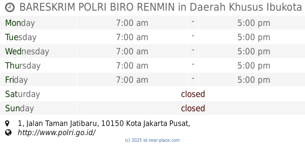
BARESKRIM POLRI BIRO RENMIN
Jalan Taman Jatibaru No.1, RT.14/RW.1, Cideng
Police
read more
890 m
CCIC
Jalan Taman Jatibaru No.1, RT.14/RW.1, Cideng
Police
read more
902 m
Direktorat Cybercrime Mabes Polri
14, RT.14/RW.1, Cideng
Police
read more
924 m
Metro Police Gambir - Jakarta
Jalan Cideng Barat Dalam No.12, RT.13/RW.1, Cideng
Police
read more
1.216 km
Pospol Pecenongan
Jl. Merdeka Barat, RT.5/RW.2, Gambir
Police
read more
1.233 km
Pospol Thamrin
Jalan M.H. Thamrin RT.1/RW.5, Menteng
Police
read more
1.634 km
Polsubsektor Cut Meutia
Jalan Cut Meutia No. 13, Cikini, Menteng, RT.2/RW.3, Gondangdia
Police
read more
1.706 km
Pospol Cut Mutiah
Jalan Taman Cut Mutiah RT.4/RW.9, Kebon Sirih
Police
read more
1.721 km
Pos Polisi
RT.5/RW.2, Gambir, RT.5/RW.2, Gambir
Police
read more
1.87 km
Polsek Metro Sarinah
menteng, RT.3/RW.9, Kebon Sirih
Police
read more
1.904 km
Pospol Majapahit
Jalan Majapahit RT.2/RW.3, Petojo Selatan
Police
read more
1.918 km
Police Metro Tanah Abang
Jalan Penjernihan I No.8, RT.4/RW.7, Bendungan Hilir, Tanah Abang
Police
read more
1.942 km
Kantor Detasemen Gegana Polda Metro Jaya
Jl. KS Tubun 3, Slipi, Palmerah
Police
read more
1.952 km
Pos Polisi Teuku Umar
Jalan Teuku Umar No.49, RT.5/RW.5, Menteng
Police
read more
1.979 km
Pos Polantas
RT.16/RW.1, Cikini
Police
read more
1.994 km
Gegana Polda Metro Jaya
Jalan Aipda Ks.Tubun III No.7c, RT.13/RW.6, Slipi
Police
read more
2.101 km
polisi subsektor palmerah
Jalan Ks. Tubun No.134, RT.1/RW.7, Slipi
Police
read more
2.227 km
Pospol Suropati
Jalan Taman Suropati, RT. 5/RW. 5, Menteng, RT.5/RW.5, Menteng
Police
read more
📑
all categories
Accounting
Administrative area level 1
Administrative area level 2
Airport
Amusement park
Aquarium
Art gallery
Atm
Bakery
Bank
Bar
Beauty salon
Bicycle store
Book store
Bowling alley
Bus station
Cafe
Campground
Car dealer
Car rental
Car repair
Car wash
Casino
Cemetery
Church
City hall
Clothing store
Colloquial area
Convenience store
Courthouse
Dentist
Department store
Doctor
Electrician
Electronics store
Embassy
Finance
Fire station
Florist
Food
Funeral home
Furniture store
Gas station
General contractor
Grocery or supermarket
Gym
Hair care
Hardware store
Health
Hindu Temple
Home goods store
Hospital
Insurance agency
Intersection
Jewelry store
Laundry
Lawyer
Library
Liquor store
Local government office
Locality
Locksmith
Lodging
Meal delivery
Meal takeaway
Mosque
Movie rental
Movie theater
Moving company
Museum
Natural feature
Neighborhood
Night club
Painter
Park
Parking
Pet store
Pharmacy
Physiotherapist
Place of worship
Plumber
Point of interest
Police
Political
Post office
Premise
Real estate agency
Restaurant
Roofing contractor
Route
Rv park, camping
School
Shoe store
Shopping mall
Spa
Stadium
Storage
Store
Subpremise
Supermarket
Synagogue
Taxi stand
Train station
Transit station
Travel agency
University
Veterinary care
Zoo
administrative area level 3
administrative area level 4
administrative area level 5
sublocality level 1
↑