Park nearby Taman Sehati
Coronavirus disease (COVID-19) Situation
confirmed cases
6829221
deaths
162063
Indonesia
Park nearby Taman Sehati
Taman Sehati
cikarang setadion wibawa mukti, Sertajaya, Cikarang Tim., Bekasi, Jawa Barat 17530, Indonesia
contacts phone
:
+62
Latitude:
-6.3115912
, Longitude:
107.1799155
larger map & directions
read more
nearest Park
3.169 km
Meikarta Centralpark
Unnamed Road, Sel., Cibatu
Park
read more
3.467 km
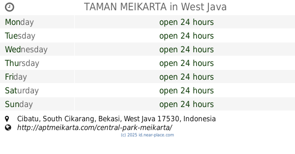
Taman MEIKARTA cikarang
Cibatu
Park
read more
3.498 km
MEIKARTA - Central Park
Jayamukti
Park
read more
3.516 km
TAMAN MEIKARTA
Cibatu
Park
read more
3.569 km
Fasum
No.,, Jalan Cimandiri 2G No.25, Jatireja
Park
read more
3.591 km
Pt Ebara
Pasirsari
Park
read more
4.007 km
Forest Green Lippo Cikarang
Jalan Gunung Batur No.17, Cibatu
Park
read more
4.018 km
Kost Tedi Wijaya
Pasirgombong
Park
read more
4.64 km
Miftahul Fauzi
Jalan Desa Pasir Gombong, Pasirgombong
Park
read more
4.777 km
Danau Ellysium
Cibatu
Park
read more
4.9 km
Kefir Kitchen
Cibatu
Park
read more
5.066 km
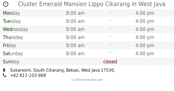
Cluster Emerald Mansion Lippo Cikarang
Sukaresmi
Park
read more
5.27 km
PT AJE INDONESIA
Jalan Damar, Cibatu
Park
read more
5.958 km
Playground Acacia
Cicau
Park
read more
6.295 km
Lapangan Sepak Bola Buni Asih
Blok V No., Jalan Jababeka IV-E Blok V No.82, Karangbaru
Park
read more
9.095 km
pos security blok O
Perumahan Gramapuri persada, Sukajaya
Park
read more
10.368 km
Cluster Parks Kemanggisan
Jalan Taman Kemanggisan No.11/42, Telagamurni
Park
read more
11.146 km
Park City Cibitung
Jalan Raya Teuku Umar No.89, Telaga Asih
Park
read more
11.945 km
Nanang DCBi
perum kota serang baru blok f29 no, RW.08, Sirnajaya
Park
read more
12.372 km
Balong Bah Ewon Tunggak Jati
Jalan Raya Rengasdengklok, No.55, Karawang Barat, Tanjungmekar
Park
read more
12.416 km
griya perum mangkalaya
blok c8 no, Calle Indonesia No.5
Park
read more
12.542 km
Taman Kota
No., Jalan Arif Rahman Hakim No.123, Karawang Kulon
Park
read more
14.109 km
Taman Ibu
Jalan Parahyangan No.46, Adiarsa Barat
Park
read more
14.433 km
Toyota Mania Tambun Bekasi
Jalan Rambutan No.787, Tridaya Sakti
Park
read more
15.809 km
Lapangan RW 015
Jalan Pahlawan 3F, Mangunjaya
Park
read more
📑
all categories
Accounting
Administrative area level 1
Administrative area level 2
Airport
Amusement park
Aquarium
Art gallery
Atm
Bakery
Bank
Bar
Beauty salon
Bicycle store
Book store
Bowling alley
Bus station
Cafe
Campground
Car dealer
Car rental
Car repair
Car wash
Casino
Cemetery
Church
City hall
Clothing store
Colloquial area
Convenience store
Courthouse
Dentist
Department store
Doctor
Electrician
Electronics store
Embassy
Finance
Fire station
Florist
Food
Funeral home
Furniture store
Gas station
General contractor
Grocery or supermarket
Gym
Hair care
Hardware store
Health
Hindu Temple
Home goods store
Hospital
Insurance agency
Intersection
Jewelry store
Laundry
Lawyer
Library
Liquor store
Local government office
Locality
Locksmith
Lodging
Meal delivery
Meal takeaway
Mosque
Movie rental
Movie theater
Moving company
Museum
Natural feature
Neighborhood
Night club
Painter
Park
Parking
Pet store
Pharmacy
Physiotherapist
Place of worship
Plumber
Point of interest
Police
Political
Post office
Premise
Real estate agency
Restaurant
Roofing contractor
Route
Rv park, camping
School
Shoe store
Shopping mall
Spa
Stadium
Storage
Store
Subpremise
Supermarket
Synagogue
Taxi stand
Train station
Transit station
Travel agency
University
Veterinary care
Zoo
administrative area level 3
administrative area level 4
administrative area level 5
sublocality level 1
↑