Park nearby Lapangan Kemiri
Coronavirus disease (COVID-19) Situation
confirmed cases
6829221
deaths
162063
Indonesia
Park nearby Lapangan Kemiri
Lapangan Kemiri
Jalan Kemiri II, Pondok Cabe Udik Indonesia
contacts phone
:
+62
Latitude:
-6.3479515
, Longitude:
106.7593143
read more
nearest Park
1.013 km
Gerbang Hitam
Jalan Kesehatan I, Cipayung
Park
read more
1.15 km
Kolam Renang Rosewood Residence
Jalan Pala Raya No.8, Pondok Cabe Udik
Park
read more
1.183 km
Danau UT
Jalan Talas III No.4, Pondok Cabe Ilir
Park
read more
1.397 km
Ralin BC
Jalan terminal Pondok Cabe(Kh. Salem), Pondok Cabe Udik
Park
read more
1.548 km
Taman Warga Bukit Cinere Indah
Taman Pesanggrahan 3, Cinere
Park
read more
1.585 km
Taman Tranquility Modernhill
Cinangka
Park
read more
1.596 km
Chilihut Gateball Court
B 14, Jalan Taman Pondok Cabe No.5, Kedaung
Park
read more
1.674 km
Kampus Bamboe
No., Jalan Tanah Merah No.56, Pondok Cabe Ilir
Park
read more
1.707 km
Komplek Pamulang Estat
Jalan Cempedak Raya, Pamulang Timur
Park
read more
1.712 km
Alterra residence Ciputat
No.53, Jalan Cipunegara No.2, Cipayung
Park
read more
1.715 km
Komplek Pamulang Indah MA GrabBike
Jalan Wijaya Kusuma, Pamulang Timur
Park
read more
1.781 km
Fishing Ponds Kiray
Jalan Kedaung No.45, Cinangka
Park
read more
1.783 km
Lapangan Bhineka
Jalan Raya Vila Inti Persada, Pamulang Timur
Park
read more
1.784 km
Lapangan Serbaguna
Jalan Wisata, Cipayung
Park
read more
1.86 km
Sanggar IpunK
Jalan Kelor III No.48A, Pondok Cabe Ilir
Park
read more
1.939 km
Vila Inti Persada GrabBike
No.C1/15, Jalan Alam Hijau, Pamulang Timur
Park
read more
1.949 km
Sekretariat Rafpala
Jalan Talas 2 No.19, Pondok Cabe Ilir
Park
read more
2.003 km
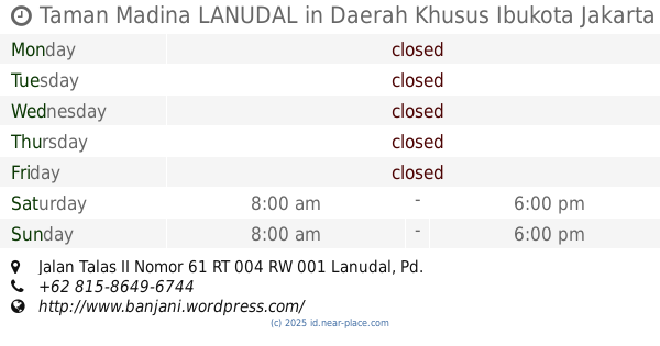
Taman Madina LANUDAL
Jalan Talas II Nomor 61 RT 004 RW 001 Lanudal, Pondok Cabe Ilir
Park
read more
2.008 km
Limo Enduro Track
Limo
Park
read more
2.011 km
Limo Enduro Circuit
Jalan Swadaya, Grogol
Park
read more
2.313 km
Taman Patung Kuda
Perum Estate. Pamulang Kota Tangerang Slatan. 15417, Pamulang Timur
Park
read more
2.555 km
Taman Warga Bukit Cirendeu
Pisangan
Park
read more
3.03 km
Taman Pamulang Permai 1
West Pamulang
Park
read more
3.975 km
Gojek Camp
Jalan Manggis Raya No.333, Cinere
Park
read more
4.055 km
Danau Cinere Pangkalan Jati
Pangkalan Jati
Park
read more
📑
all categories
Accounting
Administrative area level 1
Administrative area level 2
Airport
Amusement park
Aquarium
Art gallery
Atm
Bakery
Bank
Bar
Beauty salon
Bicycle store
Book store
Bowling alley
Bus station
Cafe
Campground
Car dealer
Car rental
Car repair
Car wash
Casino
Cemetery
Church
City hall
Clothing store
Colloquial area
Convenience store
Courthouse
Dentist
Department store
Doctor
Electrician
Electronics store
Embassy
Finance
Fire station
Florist
Food
Funeral home
Furniture store
Gas station
General contractor
Grocery or supermarket
Gym
Hair care
Hardware store
Health
Hindu Temple
Home goods store
Hospital
Insurance agency
Intersection
Jewelry store
Laundry
Lawyer
Library
Liquor store
Local government office
Locality
Locksmith
Lodging
Meal delivery
Meal takeaway
Mosque
Movie rental
Movie theater
Moving company
Museum
Natural feature
Neighborhood
Night club
Painter
Park
Parking
Pet store
Pharmacy
Physiotherapist
Place of worship
Plumber
Point of interest
Police
Political
Post office
Premise
Real estate agency
Restaurant
Roofing contractor
Route
Rv park, camping
School
Shoe store
Shopping mall
Spa
Stadium
Storage
Store
Subpremise
Supermarket
Synagogue
Taxi stand
Train station
Transit station
Travel agency
University
Veterinary care
Zoo
administrative area level 3
administrative area level 4
administrative area level 5
sublocality level 1
↑