Night club nearby Audi's Residence Lounge
Coronavirus disease (COVID-19) Situation
confirmed cases
6829221
deaths
162063
Indonesia
Night club nearby Audi's Residence Lounge
Audi's Residence Lounge
Jalan Paranti Sejahtera, 17415, Kota Bekasi, Jawa Barat, ID Indonesien
contacts phone
:
+62
website:
audiathome.com
Latitude:
-6.3018804
, Longitude:
106.9295256
larger map & directions
read more
nearest Night club
1.051 km
Warung Seblak Mama Kicok
Gang Haji Semplo No.95a, Jatirahayu
Night club
read more
1.116 km
UBER USA Purgad Legok
Jalan Palem Raya, Jatimekar
Night club
read more
1.126 km
Elank Cianjour
Rumah Sakit Umum Masmitra, Jalan Jati Makmur No.40, Jakasampurna
Night club
read more
1.579 km
Bajang Reborn Studio
Jalan Raya Hankam, Jatirahayu
Night club
read more
1.66 km
TRABLE
Jalan Anugrah, Jatimakmur
Night club
read more
1.671 km
Star Cute Detailing
Jalan Setu Raya No.14, RT.5/RW.1, Setu
Night club
read more
1.85 km
SETU TABLE TENNIS PREMIER CLUB
Jalan Raya Setu No.8, RT.6/RW.5, Setu
Night club
read more
1.934 km
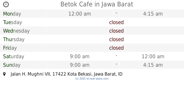
Betok Cafe
Jalan H. Mughni VII, Jatimekar
Night club
read more
1.978 km
SHELTER KBLB JATIMAKMUR
Jalan Jati Makmur No.:55, Jatimakmur
Night club
read more
2.086 km
Legend Of Losmen
Jalan Durian XVIII, Padurenan
Night club
read more
2.107 km
Gerah Ladur
Blok Soka No.65, Jalan Swadaya Rawa Binong RT.5/RW.3, Bambu Apus
Night club
read more
2.111 km
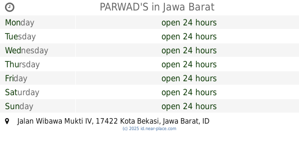
PARWAD'S
Jalan Wibawa Mukti IV, Jatimekar
Night club
read more
2.221 km
Amsher Soldier
Jalan Kampung Keramat RT.7/RW.4, Setu
Night club
read more
2.279 km
Kolam Ageng
Jalan Bambu Apus Raya Blok Waru No.9, RT.12/RW.3, Bambu Apus
Night club
read more
2.29 km
Markas Gerah Ladur
Jalan Mini III No.RT.12, RW.3, Bambu Apus
Night club
read more
2.334 km
Warkop Bang Aep.
Blok Kramat 4, Jalan Rawa Binong Blok Kramat 4 No.46, RT.9/RW.10, Lubang Buaya
Night club
read more
2.408 km
Studio Musik Ready
No., Jalan Kramat Tiga.I RT.7/RW.10, Lubang Buaya
Night club
read more
2.536 km
Warnet & Ps 2
Jalan Raya Kampung Sawah Jati Murni Pondok Melati No.39, Jatimelati
Night club
read more
2.822 km
SAUNG APEL 8
Jalan Apel VIII Blok D10 No.6, Jatimekar
Night club
read more
2.865 km
Inul Vizta Pondok Gede
Plaza Pondok Gede Lt. 2, Jalan Raya Pondok Gede No.1, Jatiwaringin, Pondokgede, Jatiwaringin, Kota Bks
Night club
read more
2.886 km
ADi's Corner's
Jalan Haji Gemin No.27-100, Jatikramat
Night club
read more
2.893 km
Club Sinc
Ruko Plaza Pondok Gede, Jalan Raya Pondok Gede Blok C No.14-15, RT.1/RW.12, Jatiwaringin
Night club
read more
3.049 km
V.R.C Lubang Buaya
B, Jalan Al.Baidho I No.74, RT.2/RW.6, Lubang Buaya
Night club
read more
3.418 km
Warung & Bengkel KADE
Jalan Bambu Wulung 1 No.3, RT.10/RW.5, Setu
Night club
read more
3.487 km
Susu Jahe Merah Pinang Muda
Jalan Bagol, Jatisari
Night club
read more
📑
all categories
Accounting
Administrative area level 1
Administrative area level 2
Airport
Amusement park
Aquarium
Art gallery
Atm
Bakery
Bank
Bar
Beauty salon
Bicycle store
Book store
Bowling alley
Bus station
Cafe
Campground
Car dealer
Car rental
Car repair
Car wash
Casino
Cemetery
Church
City hall
Clothing store
Colloquial area
Convenience store
Courthouse
Dentist
Department store
Doctor
Electrician
Electronics store
Embassy
Finance
Fire station
Florist
Food
Funeral home
Furniture store
Gas station
General contractor
Grocery or supermarket
Gym
Hair care
Hardware store
Health
Hindu Temple
Home goods store
Hospital
Insurance agency
Intersection
Jewelry store
Laundry
Lawyer
Library
Liquor store
Local government office
Locality
Locksmith
Lodging
Meal delivery
Meal takeaway
Mosque
Movie rental
Movie theater
Moving company
Museum
Natural feature
Neighborhood
Night club
Painter
Park
Parking
Pet store
Pharmacy
Physiotherapist
Place of worship
Plumber
Point of interest
Police
Political
Post office
Premise
Real estate agency
Restaurant
Roofing contractor
Route
Rv park, camping
School
Shoe store
Shopping mall
Spa
Stadium
Storage
Store
Subpremise
Supermarket
Synagogue
Taxi stand
Train station
Transit station
Travel agency
University
Veterinary care
Zoo
administrative area level 3
administrative area level 4
administrative area level 5
sublocality level 1
↑