Natural feature nearby Ci Limus
Coronavirus disease (COVID-19) Situation
confirmed cases
6829221
deaths
162063
Indonesia
Natural feature nearby Ci Limus
Ci Limus
Ci Limus, Babakan, Babakan Ciparay, Kota Bandung, Jawa Barat, Indonesia
contacts phone
:
+62
Latitude:
-6.9355556
, Longitude:
107.5772222
larger map & directions
read more
nearest Natural feature
1.561 km
Situ Aksan
Indonesia
Natural feature
read more
2.766 km
KAGE (Kafe Gerobak)
Jalan Raya Cibaduyut, Cibaduyut
Natural feature
read more
3.13 km
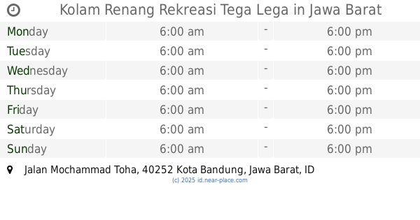
Kolam Renang Rekreasi Tega Lega
Taman Konservasi Tega Lega, Jalan Mochammad Toha, Ciateul
Natural feature
read more
3.446 km
Nyinyo
Ruko TKI Prapatan Sadang, Jalan Taman Kopo Indah No.1, Margahayu Tengah
Natural feature
read more
3.936 km
Ci Kamandilan
Indonesia
Natural feature
read more
4.006 km
Kali Bobojong
Indonesia
Natural feature
read more
4.193 km
Situ Ciparay
Indonesia
Natural feature
read more
4.31 km
PD Mega
Jalan Cikawao No.49, Paledang
Natural feature
read more
4.768 km
Ci Kungkurrak
Indonesia
Natural feature
read more
5.071 km
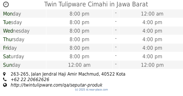
Twin Tulipware Cimahi
Jalan Jendral Haji Amir Machmud No.263-265, Cigugur Tengah
Natural feature
read more
5.074 km
Ci Keueus
Indonesia
Natural feature
read more
5.084 km
Ci Guriang
Indonesia
Natural feature
read more
5.812 km
Situ Hiyang
Indonesia
Natural feature
read more
5.869 km
Gunung Korehkotok
Indonesia
Natural feature
read more
6.082 km
Gunung Gajahlangu
Indonesia
Natural feature
read more
6.704 km
Gunung Leutik
Indonesia
Natural feature
read more
6.877 km
Ci Gede
Indonesia
Natural feature
read more
7.312 km
Situ Tekno Telkom University
Jalan Telekomunikasi No.1, Terusan Buah Batu, Dayeuhkolot, Sukapura
Natural feature
read more
7.486 km
Pasir Bodjong-kidul
Indonesia
Natural feature
read more
9.141 km
Gunung Bohong
Indonesia
Natural feature
read more
9.18 km
Gunung Jatinunggal
Indonesia
Natural feature
read more
11.147 km
Pasir Goleah
Indonesia
Natural feature
read more
12.581 km
Situ Enda
Indonesia
Natural feature
read more
12.655 km
Situ Pariuk
Indonesia
Natural feature
read more
15.152 km
Pasir Gede
Indonesia
Natural feature
read more
📑
all categories
Accounting
Administrative area level 1
Administrative area level 2
Airport
Amusement park
Aquarium
Art gallery
Atm
Bakery
Bank
Bar
Beauty salon
Bicycle store
Book store
Bowling alley
Bus station
Cafe
Campground
Car dealer
Car rental
Car repair
Car wash
Casino
Cemetery
Church
City hall
Clothing store
Colloquial area
Convenience store
Courthouse
Dentist
Department store
Doctor
Electrician
Electronics store
Embassy
Finance
Fire station
Florist
Food
Funeral home
Furniture store
Gas station
General contractor
Grocery or supermarket
Gym
Hair care
Hardware store
Health
Hindu Temple
Home goods store
Hospital
Insurance agency
Intersection
Jewelry store
Laundry
Lawyer
Library
Liquor store
Local government office
Locality
Locksmith
Lodging
Meal delivery
Meal takeaway
Mosque
Movie rental
Movie theater
Moving company
Museum
Natural feature
Neighborhood
Night club
Painter
Park
Parking
Pet store
Pharmacy
Physiotherapist
Place of worship
Plumber
Point of interest
Police
Political
Post office
Premise
Real estate agency
Restaurant
Roofing contractor
Route
Rv park, camping
School
Shoe store
Shopping mall
Spa
Stadium
Storage
Store
Subpremise
Supermarket
Synagogue
Taxi stand
Train station
Transit station
Travel agency
University
Veterinary care
Zoo
administrative area level 3
administrative area level 4
administrative area level 5
sublocality level 1
↑