Mosque nearby Masjid Utsman Bin Affan - Ciburial Bogor
Indonesia
Mosque nearby Masjid Utsman Bin Affan - Ciburial Bogor
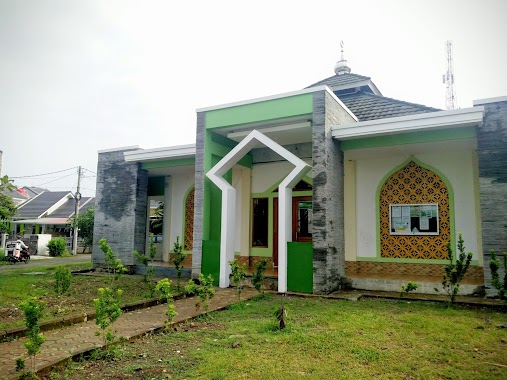
Masjid Utsman Bin Affan - Ciburial Bogor
Jalan Ciburial, 16157, Kota Bogor, Jawa Barat, ID Indonesia
contacts phone
:
+62 859-5958-8841
Latitude:
-6.5446719
, Longitude:
106.8159827
larger map & directions
read more
nearest Mosque
273 m
Masjid Al Hidayah
Ciparigi RT. 1 RW. 1, Bogor Utara, Ciparigi
Mosque
read more
384 m
Masjid Al-muttaqin
Jalan Alternative VBI I, Ciparigi
Mosque
read more
531 m
Mushola Al-Hikmah Kaum
Jalan Kampung Kaum No.16, Ciparigi
Mosque
read more
535 m
Masjid Jami Al Ukhuwah
Jalan Villa Bogor Indah Blok EE3 No.5, Ciparigi
Mosque
read more
563 m
Masjid Baiturrahiim
Jalan Villa Bogor Indah Blok EE4 No.1, Ciparigi
Mosque
read more
597 m
Masjid Mush'ab Bin Umair
Ciparigi
Mosque
read more
602 m
Masjid Jami Kaum Hubbussalam
Jalan Kampung Kaum No.7, Ciparigi
Mosque
read more
605 m
Masjid AN-NUR
Jalan Siaga, Cimandala
Mosque
read more
635 m
Masjid Baitul Mukminin
Blok 16157, Jalan Perumahan Ciparigi Indah Blok F No.12, Ciparigi
Mosque
read more
640 m
Masjid Al Hidayah
Jalan Pend. Agama No.50, Ciparigi
Mosque
read more
696 m
Masjid LDII Al-Falah
Jalan Alternative VBI I, Ciparigi
Mosque
read more
785 m
Mushola Al Ikhlash
Pasir Jambu
Mosque
read more
793 m
Mushola Al - Ghopar
Kp. Mandala RT 03 RW 009, Kampung Parung Jambu, Ciparigi
Mosque
read more
810 m
Mesjid Al-mutaqien
Jalan Mandala No.51A, Ciparigi
Mosque
read more
830 m
Masjid Atap Hijau
Jalan Mandala Raya No.51A, Ciparigi
Mosque
read more
846 m
Musholla An Nur
kp kebon rumput rt 05 rw 03, Pasir Jambu
Mosque
read more
871 m
Masjid Jami Al-Ukhuwwah
Komplek, Jalan Villa Bogor Indah 5, Pasir Jambu
Mosque
read more
901 m
Masjid Baitul Maqdis VBI 5
Jalan Villa Bogor Indah V, Pasir Jambu
Mosque
read more
914 m
Masjid Nuruzh-Zhulam
Jalan Pembangunan No.35, Kedunghalang
Mosque
read more
924 m
Masjid Mahabbaturrasul
Jalan Villa Bogor Indah No.28, Kedunghalang
Mosque
read more
1.043 km
Masjid Mardhotillah
Jalan Neglasari I, Rt. 02 / Rw. 04, Cibuluh
Mosque
read more
1.083 km
Mushola Darul Khoer
komplek pgri IV rt03 rw12, Kedunghalang
Mosque
read more
1.139 km
Masjid Pangkalan3 Pasir Jambu
Jalan Swadaya No.42, Pasir Jambu
Mosque
read more
1.254 km
Masjid Daruttamam
Jalan Rinjani, Tanah Baru
Mosque
read more
1.254 km
Masjid Daruttamam
Jalan Markisa, Tanah Baru
Mosque
read more
📑
all categories
Accounting
Administrative area level 1
Administrative area level 2
Airport
Amusement park
Aquarium
Art gallery
Atm
Bakery
Bank
Bar
Beauty salon
Bicycle store
Book store
Bowling alley
Bus station
Cafe
Campground
Car dealer
Car rental
Car repair
Car wash
Casino
Cemetery
Church
City hall
Clothing store
Colloquial area
Convenience store
Courthouse
Dentist
Department store
Doctor
Electrician
Electronics store
Embassy
Finance
Fire station
Florist
Food
Funeral home
Furniture store
Gas station
General contractor
Grocery or supermarket
Gym
Hair care
Hardware store
Health
Hindu Temple
Home goods store
Hospital
Insurance agency
Intersection
Jewelry store
Laundry
Lawyer
Library
Liquor store
Local government office
Locality
Locksmith
Lodging
Meal delivery
Meal takeaway
Mosque
Movie rental
Movie theater
Moving company
Museum
Natural feature
Neighborhood
Night club
Painter
Park
Parking
Pet store
Pharmacy
Physiotherapist
Place of worship
Plumber
Point of interest
Police
Political
Post office
Premise
Real estate agency
Restaurant
Roofing contractor
Route
Rv park, camping
School
Shoe store
Shopping mall
Spa
Stadium
Storage
Store
Subpremise
Supermarket
Synagogue
Taxi stand
Train station
Transit station
Travel agency
University
Veterinary care
Zoo
administrative area level 3
administrative area level 4
administrative area level 5
sublocality level 1
↑