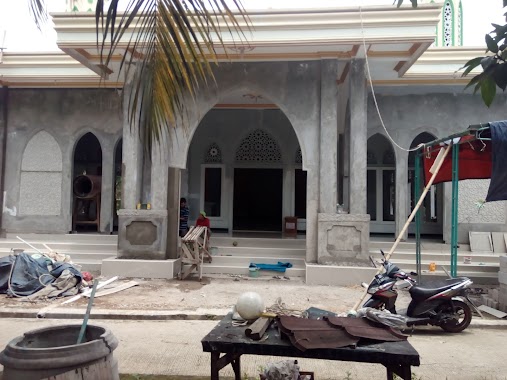
Mosque nearby Masjid Jamie Al-Hidayah
Indonesia
Mosque nearby Masjid Jamie Al-Hidayah
Masjid Jamie Al-Hidayah
Dayeuh, Cileungsi, Bogor, West Java 16820, Indonesia
contacts phone
:
+62
Latitude:
-6.4359335
, Longitude:
106.9552423
larger map & directions
read more
nearest Mosque
284 m
Masjid Al-Istiqomah
Jalan Raya Narogong No.438, Dayeuh
Mosque
read more
326 m
Masjid Jami Al Isti'adah
Dayeuh
Mosque
read more
501 m
Mushola Miftahul fallah
Jalan Raya Narogong No.438, Dayeuh
Mosque
read more
634 m
Masjid Darul Arqom
Jalan Cagak, Klapanunggal
Mosque
read more
665 m
MUSHOLA AL-MUNAWARAH
Dayeuh
Mosque
read more
722 m
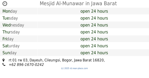
Mesjid Al-Munawar
rt 01 rw 03, Dayeuh
Mosque
read more
761 m
Musholla Nurul Iman
Klapanunggal
Mosque
read more
852 m
Mushola daarul mutaqin
Dayeuh
Mosque
read more
882 m
Masjid Al - Ghorib
Dayeuh
Mosque
read more
902 m
Masjid Baiturrahman
Dayeuh
Mosque
read more
923 m
Masjid Daruttauhid
Klapanunggal
Mosque
read more
1.06 km
Mushola Al Awabin Sindanglengo
Klapanunggal
Mosque
read more
1.077 km
Masjid Jamie Al Hikmah
Jalan Raya Narogong, Klapanunggal
Mosque
read more
1.109 km
Masjid Jamil Ar Ridwan
Dayeuh
Mosque
read more
1.279 km
Mushola Darrut Taqwa
Klapanunggal
Mosque
read more
1.318 km
Musholla Attaqwa
Dayeuh
Mosque
read more
1.34 km
Masjid Al Barokah Ghoiru Jami' Cluster Bromo Klapanunggal
Dayeuh
Mosque
read more
1.431 km
Musholla Nurul Hidayah
Klapanunggal
Mosque
read more
1.474 km
Mushola Al Istiqomah
Dayeuh
Mosque
read more
1.533 km
masjid Nurul Hidayah
Kembang Kuning
Mosque
read more
1.761 km
Masjid Jami' Nurul Amal
Unnamed Road, Klp. Nunggal, Kembang Kuning
Mosque
read more
1.773 km
Masjid Jami' Nurul Amal
Kp. Tegal, RT. 20 / 06, Kelapa Nunggal, Kembang Kuning
Mosque
read more
1.966 km
Musholah catelia
Klapanunggal
Mosque
read more
2.484 km
Masjid Jami Annur Rawa Ilat
kampung rawa ilat rt 03 rw 09, Dayeuh
Mosque
read more
2.511 km
Masjid Ar-royan Pt. Nandya Karya Perkasa
Dayeuh
Mosque
read more
📑
all categories
Accounting
Administrative area level 1
Administrative area level 2
Airport
Amusement park
Aquarium
Art gallery
Atm
Bakery
Bank
Bar
Beauty salon
Bicycle store
Book store
Bowling alley
Bus station
Cafe
Campground
Car dealer
Car rental
Car repair
Car wash
Casino
Cemetery
Church
City hall
Clothing store
Colloquial area
Convenience store
Courthouse
Dentist
Department store
Doctor
Electrician
Electronics store
Embassy
Finance
Fire station
Florist
Food
Funeral home
Furniture store
Gas station
General contractor
Grocery or supermarket
Gym
Hair care
Hardware store
Health
Hindu Temple
Home goods store
Hospital
Insurance agency
Intersection
Jewelry store
Laundry
Lawyer
Library
Liquor store
Local government office
Locality
Locksmith
Lodging
Meal delivery
Meal takeaway
Mosque
Movie rental
Movie theater
Moving company
Museum
Natural feature
Neighborhood
Night club
Painter
Park
Parking
Pet store
Pharmacy
Physiotherapist
Place of worship
Plumber
Point of interest
Police
Political
Post office
Premise
Real estate agency
Restaurant
Roofing contractor
Route
Rv park, camping
School
Shoe store
Shopping mall
Spa
Stadium
Storage
Store
Subpremise
Supermarket
Synagogue
Taxi stand
Train station
Transit station
Travel agency
University
Veterinary care
Zoo
administrative area level 3
administrative area level 4
administrative area level 5
sublocality level 1
↑