Mosque nearby Masjid At Taqwa
Indonesia
Mosque nearby Masjid At Taqwa
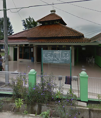
Masjid At Taqwa
Jalan Raya Serpong, 15310, Kota Tangerang Selatan, Banten, ID Indonesia
contacts phone
:
+62
Latitude:
-6.3174953
, Longitude:
106.6635454
larger map & directions
read more
nearest Mosque
89 m
Masjid Al Fattah
Jalan Raya Serpong, Serpong
Mosque
read more
299 m
Masjid Jami Ar Rohman
KP. Jaletreng, Jalan Raya Serpong RW.03, Serpong
Mosque
read more
360 m
Mushalla Al Baitul Ma'mur
Serpong
Mosque
read more
386 m
Masjid Jami Al Fattah
Jalan Roda Hias, Serpong
Mosque
read more
430 m
Masjid Koramil Serpong
Jalan Raya Serpong No. 54, Serpong
Mosque
read more
459 m
Masjid Al-Mabrur
No., Jalan Nn No.112, Serpong
Mosque
read more
506 m
Masjid al latif
Jl. Roda Hias No.30,rt 004/02 15310, Serpong
Mosque
read more
534 m
Masjid Baiturahman
Jalan Cucur Barat, Pondok Karya
Mosque
read more
541 m
Masjid Shirotol Mustaqim
Jalan Raya Serpong, Serpong
Mosque
read more
552 m
Mushola Al Barkah
Serpong
Mosque
read more
615 m
Musholla At Taqwa
Jalan Serpong No.50, Serpong
Mosque
read more
657 m
Mushola Al Hidayah
Cilenggang
Mosque
read more
694 m
Masjid Agung Al Mujahidin
Jalan Serpong No.6, Serpong
Mosque
read more
698 m
Masjid At Taqwa
Kampung Baru RT 001%2FRW 02 Pakulonan Serpong Utara Tangerang Selatan Banten, Cilenggang
Mosque
read more
852 m
Musholla Al-Hudda
Jalan Raya Serpong No.45, Serpong
Mosque
read more
931 m
Masjid Jami Al-Maghfiroh
JL. Raya Serpong, Rt. 13/05, Pondok Jagung, Serpong Utara, Serpong
Mosque
read more
1.124 km
Mushola Al Barokah
Jalan Cilenggang I No.9, Serpong, Cilenggang
Mosque
read more
1.178 km
Mushola ArRahman
Cilenggang
Mosque
read more
1.188 km
Masjid Al Aqsha de Latinos
Cluster Brazilia Delatinos BSD Serpong Serpong, Serpong
Mosque
read more
1.296 km
Masjid Baitussalam Bsd City
Jalan Pelayangan No.107, Serpong, Cilenggang
Mosque
read more
1.308 km
Mushola Nurul Iman
Jalan Cilenggang I, Cilenggang
Mosque
read more
1.622 km
Masjid Sabilun Najah
Sampora
Mosque
read more
1.779 km
Masjid Jami Nurul Huda Sampora
Jalan Alsintan No.44, Sampora
Mosque
read more
1.82 km
Masjid Miftahul Jannah
Jalan Nn No.26, RT.2/RW.2, Rawa Buntu
Mosque
read more
2.598 km
Musholla Oliander
Jalan Oliander 5 No.27, Rawa Buntu
Mosque
read more
📑
all categories
Accounting
Administrative area level 1
Administrative area level 2
Airport
Amusement park
Aquarium
Art gallery
Atm
Bakery
Bank
Bar
Beauty salon
Bicycle store
Book store
Bowling alley
Bus station
Cafe
Campground
Car dealer
Car rental
Car repair
Car wash
Casino
Cemetery
Church
City hall
Clothing store
Colloquial area
Convenience store
Courthouse
Dentist
Department store
Doctor
Electrician
Electronics store
Embassy
Finance
Fire station
Florist
Food
Funeral home
Furniture store
Gas station
General contractor
Grocery or supermarket
Gym
Hair care
Hardware store
Health
Hindu Temple
Home goods store
Hospital
Insurance agency
Intersection
Jewelry store
Laundry
Lawyer
Library
Liquor store
Local government office
Locality
Locksmith
Lodging
Meal delivery
Meal takeaway
Mosque
Movie rental
Movie theater
Moving company
Museum
Natural feature
Neighborhood
Night club
Painter
Park
Parking
Pet store
Pharmacy
Physiotherapist
Place of worship
Plumber
Point of interest
Police
Political
Post office
Premise
Real estate agency
Restaurant
Roofing contractor
Route
Rv park, camping
School
Shoe store
Shopping mall
Spa
Stadium
Storage
Store
Subpremise
Supermarket
Synagogue
Taxi stand
Train station
Transit station
Travel agency
University
Veterinary care
Zoo
administrative area level 3
administrative area level 4
administrative area level 5
sublocality level 1
↑