Mosque nearby Masjid Al-Maghfirah Karame
Coronavirus disease (COVID-19) Situation
confirmed cases
6829221
deaths
162063
Indonesia
Mosque nearby Masjid Al-Maghfirah Karame
Masjid Al-Maghfirah Karame
Karame, Singkil, Manado City, North Sulawesi, Indonezja
contacts phone
:
+62
Latitude:
1.4907454
, Longitude:
124.848428
larger map & directions
read more
nearest Mosque
270 m
Masjid K. Haji Arsyad Thawil
Jalan Sudirman 10, Komo Luar
Mosque
read more
347 m
Masjid Habib Alwi bin Smith
Karame
Mosque
read more
366 m
Masjid Al Amanah Mahakam
Wawonasa
Mosque
read more
464 m
Masjid Al-Muhajirin Wonasa
Wawonasa
Mosque
read more
537 m
Musholla At-Taqwa
Unnamed Road, Ternate Baru
Mosque
read more
611 m
Masjid Nurul Huda
Ketang Baru
Mosque
read more
667 m
Masjid Kampung tela
Singkil Satu
Mosque
read more
703 m
Masjid Awwabiyn Kampung Kodo
Lawangirung
Mosque
read more
762 m
Masjid Al-Misbah
Jalan Hasanuddin 2, Sindulang Satu
Mosque
read more
810 m
Masjid Qordova
JL. Walanda Maramis, Komplek Kampus Stain I, Pinaesaan
Mosque
read more
837 m
Masjid Acmugassirin
Desa Kleak Lingk IV, Pinaesaan
Mosque
read more
888 m
Masjid Al-Falah Sindulang
Sindulang Satu
Mosque
read more
947 m
Masjid Darussalam
Dendengan Luar
Mosque
read more
1.018 km
Bunayya AL-IKHLAS
Singkil Satu
Mosque
read more
1.042 km
Masjid AL-Qadir
Singkil Dua
Mosque
read more
1.066 km
Masjid Attijarah Pasar Bersehati Manado
Calaca
Mosque
read more
1.082 km
Nurul Iman Mosque
Jalan Soputan, Singkil Dua
Mosque
read more
1.252 km
Masjid Al Muhajirin
Singkil Dua
Mosque
read more
1.258 km
Masjid Uswatun Hasanah Banjer
Banjer
Mosque
read more
1.35 km
Masjid Al Kautsar
Banjer
Mosque
read more
1.812 km
Masjid Ashabul Kahfi
Paal Dua
Mosque
read more
1.841 km
Masjid Al-Falah
Teling Atas
Mosque
read more
2.058 km
Masjid Al Iskandaria
Ranomuut
Mosque
read more
2.073 km
Masjid Nurur Rahmah Mayora
JL. Baru Lingk, Banjer
Mosque
read more
2.085 km
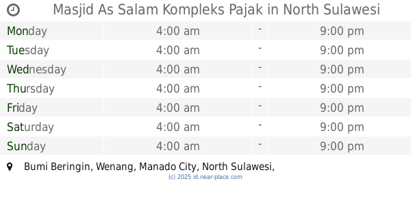
Masjid As Salam Kompleks Pajak
Bumi Beringin
Mosque
read more
📑
all categories
Accounting
Administrative area level 1
Administrative area level 2
Airport
Amusement park
Aquarium
Art gallery
Atm
Bakery
Bank
Bar
Beauty salon
Bicycle store
Book store
Bowling alley
Bus station
Cafe
Campground
Car dealer
Car rental
Car repair
Car wash
Casino
Cemetery
Church
City hall
Clothing store
Colloquial area
Convenience store
Courthouse
Dentist
Department store
Doctor
Electrician
Electronics store
Embassy
Finance
Fire station
Florist
Food
Funeral home
Furniture store
Gas station
General contractor
Grocery or supermarket
Gym
Hair care
Hardware store
Health
Hindu Temple
Home goods store
Hospital
Insurance agency
Intersection
Jewelry store
Laundry
Lawyer
Library
Liquor store
Local government office
Locality
Locksmith
Lodging
Meal delivery
Meal takeaway
Mosque
Movie rental
Movie theater
Moving company
Museum
Natural feature
Neighborhood
Night club
Painter
Park
Parking
Pet store
Pharmacy
Physiotherapist
Place of worship
Plumber
Point of interest
Police
Political
Post office
Premise
Real estate agency
Restaurant
Roofing contractor
Route
Rv park, camping
School
Shoe store
Shopping mall
Spa
Stadium
Storage
Store
Subpremise
Supermarket
Synagogue
Taxi stand
Train station
Transit station
Travel agency
University
Veterinary care
Zoo
administrative area level 3
administrative area level 4
administrative area level 5
sublocality level 1
↑