Mosque nearby Jami Masjid At-Tawbah
Coronavirus disease (COVID-19) Situation
confirmed cases
6829221
deaths
162063
Indonesia
Mosque nearby Jami Masjid At-Tawbah
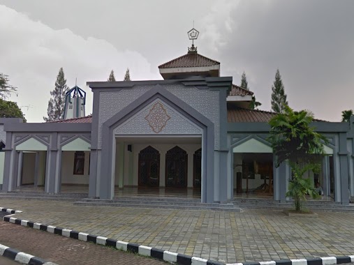
Jami Masjid At-Tawbah
Jalan Rawajati Timur II, 12750, Kota Jakarta Selatan, Daerah Khusus Ibukota Jakarta, ID Indonesia
contacts phone
:
+62
Latitude:
-6.2622031
, Longitude:
106.8536005
larger map & directions
read more
nearest Mosque
252 m
Mushola Darush Shobirin
RT.1/RW.3, Rawajati
Mosque
read more
281 m
Majelis Dzikir Rohha Al-habsyi
Jalan Rawajati Timur II No.4, RT.6/RW.2, Rawajati
Mosque
read more
457 m
Masjid Hizbul Wathon
Jalan Zeni Ad 4 RT.9/RW.3, Rawajati
Mosque
read more
469 m
Masjid Nur Amaliyah
Jalan Rawajati Timur II No.5, RT.2/RW.2, Rawajati
Mosque
read more
469 m
Musholla Nur Hidayah LDII Rawajati
Jalan Zeni Ad No.6, RT.6/RW.3, Rawajati
Mosque
read more
488 m
Masjid Hisbul Usathon
Jalan Rawajati Timur II No.5, RT.2/RW.2, Rawajati
Mosque
read more
493 m
Masjid Nurullah
Apartemen Kalibata City Tower Cendana Lt. Basement, Jl. Kalibata Raya No.1, RT.9/RW.4, Rawajati
Mosque
read more
639 m
Masjid Al Bustan
Plaza Kali Bata Lantai FF, Jalan Raya Kalibata RT.3/RW.2, Rawajati
Mosque
read more
660 m
Masjid Al - Hidayah
Jalan Kalibata Timur RT.14/RW.1, Kalibata
Mosque
read more
804 m
Masjid Nurul Hilal Kalibata
16, Jalan Raya Kalibata Blok Pelangi No.12, RT.2/RW.7, Rawajati
Mosque
read more
826 m
Masjid Ar Raudhoh
Jalan Anggrek No.42S, RT.8/RW.6, Cililitan
Mosque
read more
832 m
BCHadroh ATTAKIYF
Jalan Eretan I RT.9/RW.1, Balekambang
Mosque
read more
872 m
Musholla Al Inabah
Jalan Ciliwung No.18, RT.7/RW.6, Cililitan
Mosque
read more
904 m
Mushola al-ma'mun
Jalan Cililitan Kecil I No.11-10, RT.8/RW.7, Cililitan
Mosque
read more
910 m
Masjid Ulul Albaab (Kompleks PT Rekayasa Industri)
1, Jalan Kalibata Timur No.5, RT.2/RW.8, Kalibata
Mosque
read more
981 m
Masjid Assadah
Blok Mesjid, Jalan Masjid Baru Blok Mesjid No.39, RT.6/RW.1, Pejaten Timur
Mosque
read more
993 m
Masjid YAMP
Perumahan DPR MPR, Kalibata, Mampang Prapatan, RT.6/RW.7, Rawajati
Mosque
read more
1.005 km
Masjid Al-Amin Kompleks DPR Kalibata
Jalan Kompleks Dpr 1 RT.12/RW.5, Kalibata
Mosque
read more
1.037 km
Musholla Darull Rahman
RT.6/RW.7, Rawajati
Mosque
read more
1.071 km
Masjid Nurul Iman
JL. Kalibata, RT. 04 RW. 06, Jagakarsa, RT.14/RW.1, Kalibata
Mosque
read more
1.087 km
Masjid Al Ikhlas
JL Budi Asih, RT 06 RW 03, Kramat Jati, RT.3/RW.3, Cawang
Mosque
read more
1.117 km
Masjid As-Salam Universitas Trilogi - STEKPI
Jalan Haji Mahmud Raya No.31, RT.4/RW.4, Duren Tiga
Mosque
read more
1.156 km
Masjid Nurul Badar
Indonesia
Mosque
read more
1.156 km
Masjid Nurul Badar
Indonesien
Mosque
read more
1.175 km
Mesjid At Thayibah
Jl. Kekeran RT.3/RW.5, Cililitan, Kramatjati, RT.7/RW.5, Cililitan
Mosque
read more
📑
all categories
Accounting
Administrative area level 1
Administrative area level 2
Airport
Amusement park
Aquarium
Art gallery
Atm
Bakery
Bank
Bar
Beauty salon
Bicycle store
Book store
Bowling alley
Bus station
Cafe
Campground
Car dealer
Car rental
Car repair
Car wash
Casino
Cemetery
Church
City hall
Clothing store
Colloquial area
Convenience store
Courthouse
Dentist
Department store
Doctor
Electrician
Electronics store
Embassy
Finance
Fire station
Florist
Food
Funeral home
Furniture store
Gas station
General contractor
Grocery or supermarket
Gym
Hair care
Hardware store
Health
Hindu Temple
Home goods store
Hospital
Insurance agency
Intersection
Jewelry store
Laundry
Lawyer
Library
Liquor store
Local government office
Locality
Locksmith
Lodging
Meal delivery
Meal takeaway
Mosque
Movie rental
Movie theater
Moving company
Museum
Natural feature
Neighborhood
Night club
Painter
Park
Parking
Pet store
Pharmacy
Physiotherapist
Place of worship
Plumber
Point of interest
Police
Political
Post office
Premise
Real estate agency
Restaurant
Roofing contractor
Route
Rv park, camping
School
Shoe store
Shopping mall
Spa
Stadium
Storage
Store
Subpremise
Supermarket
Synagogue
Taxi stand
Train station
Transit station
Travel agency
University
Veterinary care
Zoo
administrative area level 3
administrative area level 4
administrative area level 5
sublocality level 1
↑