Lodging nearby Gunung Sumbul
Indonesia
Lodging nearby Gunung Sumbul
Gunung Sumbul
Gunung Indonesien
contacts phone
:
+62
Latitude:
-6.7090878
, Longitude:
106.7222106
read more
nearest Lodging
1.488 km
Hotel Seruni Gunung Salak
Pasawahan
Lodging
read more
1.488 km
Gunung Salak
Gunung Salak, Pasawahan, Cicurug, Pasawahan
Lodging
read more
1.493 km
Puncak Manik 1 Curug
Pasawahan
Lodging
read more
3.117 km
Vila Daun Pakis
Gunung Sari
Lodging
read more
3.922 km
Gerbang Utama Panorama Alam
Gunung Sari
Lodging
read more
3.954 km
Vila Betawi
Jalan Curug Cigamea, Gunung Sari
Lodging
read more
3.965 km
Villanames2 Gunung Bunder
Jalan Curug Cigamea, Gunung Sari
Lodging
read more
3.995 km
Saung Benteng
Gunung Picung
Lodging
read more
4.005 km
Villa Kaka Cimudal
Jalan Curug Cigamea, Gunung Sari
Lodging
read more
4.051 km
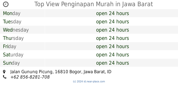
Top View Penginapan Murah
Jalan Gunung Picung, Gunung Sari
Lodging
read more
4.121 km
Villa Lembah Pesona
Jalan Gunung Picung, Gunung Sari
Lodging
read more
4.131 km
Pondok Dr Idris Idham
Gunung Sari
Lodging
read more
4.193 km
Saung Maranty ( kang Nchepz )
kp. rawa lega Rt. 02 rw 09 desa, Gunung Sari
Lodging
read more
4.637 km
Villa Jawa Bogor
Jalan Gunung Bunder, Gunung Picung
Lodging
read more
4.716 km
Sasaungan Cunang
Sukajadi
Lodging
read more
4.728 km
Pondok Salsabila
Gunung Malang
Lodging
read more
4.772 km
Poeti Mountain View Resort
Gunung Sari
Lodging
read more
4.934 km
Centhini Resort
Jalan Gunung Bunder No.2, Gunung Bunder 2
Lodging
read more
4.953 km
Villa Mount Bunder
Jalan Gunung Bunder, Gunung Bunder 2
Lodging
read more
5.028 km
Home Stay Sido Mukti Bogor
Jalan Raya Curug Nangka RT.3/RW.5, Sukajadi
Lodging
read more
5.032 km
Home Stay Deliza
Gunung Sari
Lodging
read more
5.07 km
villa bima
Gunung Sari
Lodging
read more
5.271 km
Homestay Lariska
Gunung Sari
Lodging
read more
5.369 km
Villa pondok padil
Gunung Sari
Lodging
read more
5.393 km
Villa 3 Pinang
Gunung Sari
Lodging
read more
📑
all categories
Accounting
Administrative area level 1
Administrative area level 2
Airport
Amusement park
Aquarium
Art gallery
Atm
Bakery
Bank
Bar
Beauty salon
Bicycle store
Book store
Bowling alley
Bus station
Cafe
Campground
Car dealer
Car rental
Car repair
Car wash
Casino
Cemetery
Church
City hall
Clothing store
Colloquial area
Convenience store
Courthouse
Dentist
Department store
Doctor
Electrician
Electronics store
Embassy
Finance
Fire station
Florist
Food
Funeral home
Furniture store
Gas station
General contractor
Grocery or supermarket
Gym
Hair care
Hardware store
Health
Hindu Temple
Home goods store
Hospital
Insurance agency
Intersection
Jewelry store
Laundry
Lawyer
Library
Liquor store
Local government office
Locality
Locksmith
Lodging
Meal delivery
Meal takeaway
Mosque
Movie rental
Movie theater
Moving company
Museum
Natural feature
Neighborhood
Night club
Painter
Park
Parking
Pet store
Pharmacy
Physiotherapist
Place of worship
Plumber
Point of interest
Police
Political
Post office
Premise
Real estate agency
Restaurant
Roofing contractor
Route
Rv park, camping
School
Shoe store
Shopping mall
Spa
Stadium
Storage
Store
Subpremise
Supermarket
Synagogue
Taxi stand
Train station
Transit station
Travel agency
University
Veterinary care
Zoo
administrative area level 3
administrative area level 4
administrative area level 5
sublocality level 1
↑