Local government office nearby Kantor Kelurahan Tugujaya
Indonesia
Local government office nearby Kantor Kelurahan Tugujaya
Kantor Kelurahan Tugujaya
Jalan Cibaregbeg, 46126, Tasikmalaya, Jawa Barat, ID Indonesia
contacts phone
:
+62
Latitude:
-7.3442491
, Longitude:
108.2148508
larger map & directions
read more
nearest Local government office
286 m
Perum Casablanca
Gang Haji Edi, Tugujaya
Local government office
read more
406 m
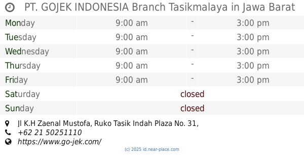
PT. GOJEK INDONESIA Branch Tasikmalaya
Jl K.H Zaenal Mustofa, Ruko Tasik Indah Plaza No. 31, Kahuripan
Local government office
read more
1.105 km
Mayasari Townhouse
Kahuripan
Local government office
read more
1.173 km
Perum TNI AD Gunung Roay
Jalan Singa II, Kahuripan
Local government office
read more
1.283 km
Department of Social, Manpower and Transmigration
Jalan Siliwangi No.73, Kahuripan
Local government office
read more
1.367 km
Kantor Kelurahan Sambong Jaya
Jalan Sambong Jaya, Sambongjaya
Local government office
read more
1.371 km
G-17
Perum Nyantong Permai G-17, Kahuripan
Local government office
read more
1.435 km
Perum Baitul Marhamah 1 Sambongjaya
Sambongjaya
Local government office
read more
1.437 km
cv kinanti putra
Kahuripan
Local government office
read more
1.444 km
Raider Infantry Brigade-13Galuh
Jalan Siliwangi No.109, Kahuripan
Local government office
read more
1.528 km
Perumahan Bening Regency
Jalan Cikunten Indah, Kahuripan
Local government office
read more
1.663 km
Kantor notaris yana maulana
Jalan Tamansari, Sambongjaya
Local government office
read more
1.777 km
Perum Batara Indah
Kahuripan, Tawang, Kahuripan
Local government office
read more
1.807 km
Perum Graha Siliwangi
Mangkubumi
Local government office
read more
1.836 km
Kantor Dinas Cipta Karya Tasikmalaya
Kahuripan
Local government office
read more
1.841 km
Bale Wiwitan
Jalan Noenoeng Tisnasaputra No.5, Kahuripan
Local government office
read more
2.351 km
Perum Wijaya Permai Blok B
jl.ambong sari, Kersanagara
Local government office
read more
2.51 km
SATPOL PP DAN DAMKAR KOTA TASIKMALAYA
Linggajaya
Local government office
read more
2.518 km
SATUAN POLISI PAMONG PRAJA KOTA TASIKMALAYA
Jalan Ir.H.Juanda, Linggajaya
Local government office
read more
2.575 km
Perumahan Bumi Resik Residence Dalima
Setiaratu
Local government office
read more
2.727 km
Perumahan Griya Cicantel Asri
Jalan Cicantel, griya asri
Local government office
read more
3.603 km
BPPT
Panglayungan
Local government office
read more
3.912 km
pesona nirwana
Jalan Letda Lily Rochli, Cipedes
Local government office
read more
4.086 km
Perum Sukamulya
Jalan Letnan Harun, Sukamulya
Local government office
read more
4.363 km
Dinas Pendidikan Kota Tasikmalaya
Kompleks Perkantoran Kota Tasikmalaya, JL. Ir. H. Juanda, Tasikmalaya, West Java, Linggajaya
Local government office
read more
📑
all categories
Accounting
Administrative area level 1
Administrative area level 2
Airport
Amusement park
Aquarium
Art gallery
Atm
Bakery
Bank
Bar
Beauty salon
Bicycle store
Book store
Bowling alley
Bus station
Cafe
Campground
Car dealer
Car rental
Car repair
Car wash
Casino
Cemetery
Church
City hall
Clothing store
Colloquial area
Convenience store
Courthouse
Dentist
Department store
Doctor
Electrician
Electronics store
Embassy
Finance
Fire station
Florist
Food
Funeral home
Furniture store
Gas station
General contractor
Grocery or supermarket
Gym
Hair care
Hardware store
Health
Hindu Temple
Home goods store
Hospital
Insurance agency
Intersection
Jewelry store
Laundry
Lawyer
Library
Liquor store
Local government office
Locality
Locksmith
Lodging
Meal delivery
Meal takeaway
Mosque
Movie rental
Movie theater
Moving company
Museum
Natural feature
Neighborhood
Night club
Painter
Park
Parking
Pet store
Pharmacy
Physiotherapist
Place of worship
Plumber
Point of interest
Police
Political
Post office
Premise
Real estate agency
Restaurant
Roofing contractor
Route
Rv park, camping
School
Shoe store
Shopping mall
Spa
Stadium
Storage
Store
Subpremise
Supermarket
Synagogue
Taxi stand
Train station
Transit station
Travel agency
University
Veterinary care
Zoo
administrative area level 3
administrative area level 4
administrative area level 5
sublocality level 1
↑