Grocery or supermarket nearby Warung Mamah Aul
Coronavirus disease (COVID-19) Situation
confirmed cases
6829221
deaths
162063
Indonesia
Grocery or supermarket nearby Warung Mamah Aul
Warung Mamah Aul
cijujujung, RT.03/RW.13, Cijujung Indonesia
contacts phone
:
+62
Latitude:
-6.5318055
, Longitude:
106.8384873
read more
nearest Grocery or supermarket
358 m
Warung Sayur Bu'de
Jalan Btn Cijunjung Permai Blok E No.17, Cijujung
Grocery or supermarket
read more
370 m
Warung Bu Gito
Tatya Asri Blok JB No.15, Cijujung
Grocery or supermarket
read more
401 m
BYEES
21, Jl.Tatya Asri II JC, Cijujung
Grocery or supermarket
read more
478 m
Warung Abang Duren
Jalan Desa Cijujung No.93, Cijujung
Grocery or supermarket
read more
479 m
Pancake Durian KHRISNA Bogor
Jalan Btn Cijunjung Permai Blok B No.6, Cijujung
Grocery or supermarket
read more
551 m
Risollis Risol Mba Lis
Jalan Btn Cijunjung Permai No.17, Cijujung
Grocery or supermarket
read more
714 m
Toko Sumardi
Jl. Jembatan hitam, Rt01 / Rw 13, No. 35, Cijujung, Sukaraja, Cijujung
Grocery or supermarket
read more
748 m
Kedai Indra
Unnamed Road, Cijujung
Grocery or supermarket
read more
822 m
Warung Bapak Aman
Kp. Legok Gaok,, Kadumangu
Grocery or supermarket
read more
840 m
Warung Tarti
Jalan Jambu 1, Cijujung
Grocery or supermarket
read more
860 m
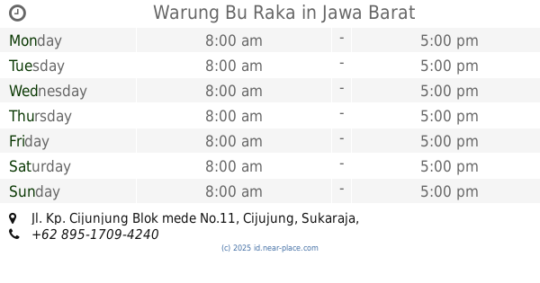
Warung Bu Raka
Jl. Kp. Cijunjung Blok mede No.11, Cijujung
Grocery or supermarket
read more
913 m
Agen BRILink Arifin Efendi
Jalan Jembatan Pari No.16, Cijujung
Grocery or supermarket
read more
927 m
Warung Firda
Unnamed Road, Cijujung
Grocery or supermarket
read more
939 m
BRILINK ARIFIN - SRC ARIFIN
Jalan Raya Bogor No.23, Cijujung
Grocery or supermarket
read more
950 m
Indomaret Dc
Jalan Jembatan Hitam, Cijujung
Grocery or supermarket
read more
1.068 km
Toko Tisa
jl. jembatan hitam rt 02 rw 10, Cijujung
Grocery or supermarket
read more
1.13 km
Wr.sembako H.ento
Jalan Raya Bogor, Cimandala
Grocery or supermarket
read more
1.177 km
Warung Lading
kp. leuwi kotok, rt 01/06. Ds. pasir laja,sukaraja. kb. jawa barar, Pasirlaya
Grocery or supermarket
read more
1.235 km
Rumah Sahrul Hidayat (Engkoh)
Jalan Alternatif Sentul No.5 C, Cijujung
Grocery or supermarket
read more
1.241 km
Warung Ikok
jln. kp leuwi kotok rt 04/06. pasir laja., Pasirlaya
Grocery or supermarket
read more
1.398 km
Ceriamart Megasentul
Jalan Bougenville VIII, Pasirlaya
Grocery or supermarket
read more
1.456 km
Alfamart Kandang Roda
Jalan Raya Bogor - Jakarta, Nanggewer
Grocery or supermarket
read more
1.865 km
Toko Anugrah
Rt 001 Rw 03 Kecamatan Citeureup, Jalan Raya Sirkuit Sentul, Sentul
Grocery or supermarket
read more
2.023 km
Toko Darma
Jalan Raya Bogor, Ciluar
Grocery or supermarket
read more
2.49 km
Toko Snack Kiloan
Jalan Roda Pembangunan Rt 003 Rw 08 No 47 Kelurahan, Nanggewer
Grocery or supermarket
read more
📑
all categories
Accounting
Administrative area level 1
Administrative area level 2
Airport
Amusement park
Aquarium
Art gallery
Atm
Bakery
Bank
Bar
Beauty salon
Bicycle store
Book store
Bowling alley
Bus station
Cafe
Campground
Car dealer
Car rental
Car repair
Car wash
Casino
Cemetery
Church
City hall
Clothing store
Colloquial area
Convenience store
Courthouse
Dentist
Department store
Doctor
Electrician
Electronics store
Embassy
Finance
Fire station
Florist
Food
Funeral home
Furniture store
Gas station
General contractor
Grocery or supermarket
Gym
Hair care
Hardware store
Health
Hindu Temple
Home goods store
Hospital
Insurance agency
Intersection
Jewelry store
Laundry
Lawyer
Library
Liquor store
Local government office
Locality
Locksmith
Lodging
Meal delivery
Meal takeaway
Mosque
Movie rental
Movie theater
Moving company
Museum
Natural feature
Neighborhood
Night club
Painter
Park
Parking
Pet store
Pharmacy
Physiotherapist
Place of worship
Plumber
Point of interest
Police
Political
Post office
Premise
Real estate agency
Restaurant
Roofing contractor
Route
Rv park, camping
School
Shoe store
Shopping mall
Spa
Stadium
Storage
Store
Subpremise
Supermarket
Synagogue
Taxi stand
Train station
Transit station
Travel agency
University
Veterinary care
Zoo
administrative area level 3
administrative area level 4
administrative area level 5
sublocality level 1
↑