Grocery or supermarket nearby Toserba Sampora
Indonesia
Grocery or supermarket nearby Toserba Sampora
Toserba Sampora
Jalan Kampung Sampora, Cibinong Indonesia
contacts phone
:
+62
Latitude:
-6.4963217
, Longitude:
106.8538914
read more
nearest Grocery or supermarket
315 m
KEFIRQU
Jalan Kampung Sampora No.7, Cibinong
Grocery or supermarket
read more
325 m
Toko Sembako Mang Endeng
Unnamed Road, Cibinong
Grocery or supermarket
read more
334 m
Warung Bubur Teh Maya
Jl Kp Sampora rt 5 rw 4, Cibinong
Grocery or supermarket
read more
610 m
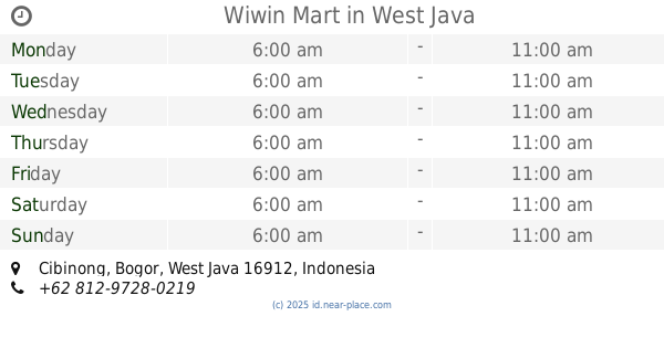
Wiwin Mart
Cibinong
Grocery or supermarket
read more
684 m
Warung Ibu Wayan
16, Jalan Wijaya Kusuma II, Cibinong
Grocery or supermarket
read more
735 m
Geo Mart
Cibinong
Grocery or supermarket
read more
874 m
Alfamart
Jalan Lanbau, Sanja
Grocery or supermarket
read more
943 m
Warung Gas Dan Es Ibu Narti
West Karang Asem
Grocery or supermarket
read more
947 m
Warung Pak Ujang(liobaru)
Jalan Kampung Gudang No No.2, Sanja
Grocery or supermarket
read more
1.026 km
Villa Kosim
Jalan Kampung Gudang No.108, Sanja
Grocery or supermarket
read more
1.042 km
Toko Simpleko
West Karang Asem
Grocery or supermarket
read more
1.434 km
Warung Alat Tulis *gilang Makmur*
Jalan Kampung Jolok Setu No.56-57, Leuwinutug
Grocery or supermarket
read more
1.495 km
Aef Home Stay
kp rt/rw 04/06 desa, Jalan Babakan Rawa Haur, Sentul
Grocery or supermarket
read more
1.496 km
Aef Speed Shoop
kp rt/rw 04/06 desa, Jalan Babakan Rawa Haur, Sentul
Grocery or supermarket
read more
1.506 km
Warung Amsar
Jalan HM. Ashari, Cibinong
Grocery or supermarket
read more
1.83 km
Tambal Ban
Jalan Kampung Curug No.63, Pakansari
Grocery or supermarket
read more
1.979 km
Warung Khansa Putri
Cibinong
Grocery or supermarket
read more
2.009 km
Warung Sayur Checep
Jalan Babakan Rawa Haur No.52-24, Sentul
Grocery or supermarket
read more
2.022 km
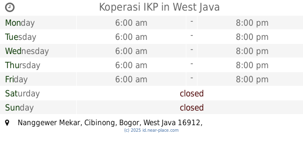
Koperasi IKP
Nanggewer Mekar
Grocery or supermarket
read more
2.038 km
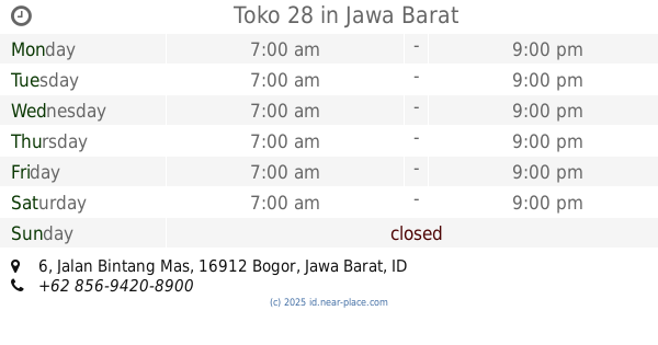
Toko 28
Jalan Bintang Mas No.6, Nanggewer
Grocery or supermarket
read more
2.091 km
Toko Koperasi Mentos
Jalan Raya Bogor - Jakarta No.6, Nanggewer
Grocery or supermarket
read more
2.157 km
Warung Lipong
Jalan Murai, Nanggewer Mekar
Grocery or supermarket
read more
2.242 km
indomart
Ciriung
Grocery or supermarket
read more
2.287 km
DEPOT AIR ISI ULANG RIZKI RAMA
Leuwinutug
Grocery or supermarket
read more
2.664 km
Isi ulang Air Ondong
Jalan Perjuangan Kampung Curug No.22, Pakansari
Grocery or supermarket
read more
📑
all categories
Accounting
Administrative area level 1
Administrative area level 2
Airport
Amusement park
Aquarium
Art gallery
Atm
Bakery
Bank
Bar
Beauty salon
Bicycle store
Book store
Bowling alley
Bus station
Cafe
Campground
Car dealer
Car rental
Car repair
Car wash
Casino
Cemetery
Church
City hall
Clothing store
Colloquial area
Convenience store
Courthouse
Dentist
Department store
Doctor
Electrician
Electronics store
Embassy
Finance
Fire station
Florist
Food
Funeral home
Furniture store
Gas station
General contractor
Grocery or supermarket
Gym
Hair care
Hardware store
Health
Hindu Temple
Home goods store
Hospital
Insurance agency
Intersection
Jewelry store
Laundry
Lawyer
Library
Liquor store
Local government office
Locality
Locksmith
Lodging
Meal delivery
Meal takeaway
Mosque
Movie rental
Movie theater
Moving company
Museum
Natural feature
Neighborhood
Night club
Painter
Park
Parking
Pet store
Pharmacy
Physiotherapist
Place of worship
Plumber
Point of interest
Police
Political
Post office
Premise
Real estate agency
Restaurant
Roofing contractor
Route
Rv park, camping
School
Shoe store
Shopping mall
Spa
Stadium
Storage
Store
Subpremise
Supermarket
Synagogue
Taxi stand
Train station
Transit station
Travel agency
University
Veterinary care
Zoo
administrative area level 3
administrative area level 4
administrative area level 5
sublocality level 1
↑