Gas station nearby Spbe Draf Gasitas
Coronavirus disease (COVID-19) Situation
confirmed cases
6829221
deaths
162063
Indonesia
Gas station nearby Spbe Draf Gasitas
Spbe Draf Gasitas
47, Jalan Raya Sukahati, 16913, Bogor, Jawa Barat, ID Indonesia
contacts phone
:
+62
Latitude:
-6.4982482
, Longitude:
106.809363
larger map & directions
read more
nearest Gas station
32 m
SPBE KOSAN - PT. Draf Gasitas
Mr. Fauzi, Cibinong, Sukahati
Gas station
read more
157 m
Sppbe
Jalan Raya Muara Beres, Sukahati
Gas station
read more
428 m
spbu mini dawamida
Sukahati
Gas station
read more
1.303 km
SPBU 34-16911
Karadenan
Gas station
read more
1.328 km
SPBU
Jalan Raya Pemda Karadenan, Karadenan, Cibinong, Karadenan
Gas station
read more
1.328 km
SPBU Sukahati - Cibinong
Jalan Raya Pemda Karadenan, Karadenan, Cibinong, Karadenan
Gas station
read more
1.343 km
Steam Gaul
Bojonggede
Gas station
read more
1.587 km
Fuel Bojong Gede
Jalan Haji Abdul Halim, Kedung Waringin
Gas station
read more
1.587 km
Pertamina Bojong Gede
Jalan Haji Abdul Halim, Kedung Waringin
Gas station
read more
1.594 km
Pertamina
Jalan Raya Bojong Gede No.10, RT.3/RW.5, Kedung Waringin
Gas station
read more
1.75 km
Jalan Setasiun Bojonggede, Pasar Lama
Gang Pasar Lama, Bojonggede
Gas station
read more
1.985 km
POMBENSIN Pertamina
Jalan Raya Bojong Gede, Bojonggede
Gas station
read more
1.998 km
SPBU 34.16123
Jalan Raya Bojong Gede, Bojong Gede, Bojonggede
Gas station
read more
2.003 km
SPBU Bojonggede
Blok C12 A, Jalan Raya Bojong Gede Blok C12 A No.12, Bojonggede
Gas station
read more
2.065 km
Pertamini
Jalan Roda Pembangunan No.45, Nanggewer
Gas station
read more
2.309 km
Pertamini Dawamida
Jalan Kampung Sawah Indah, Kedung Waringin
Gas station
read more
2.316 km
warung bensin mang anda
Jalan Kampung Sawah Indah, Bojonggede
Gas station
read more
2.421 km
Pertamina Spbu
Karadenan
Gas station
read more
2.672 km
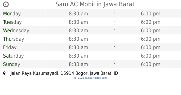
Sam AC Mobil
Jalan Raya Kusumayadi, Sukahati
Gas station
read more
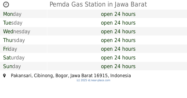
3.255 km
Pemda Gas Station
Pakansari
Gas station
read more
3.273 km
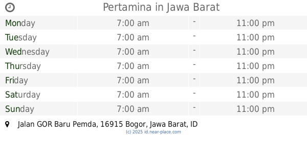
Pertamina
Jalan GOR Baru Pemda, Pakansari
Gas station
read more
3.409 km
Eni Lubricant
Jalan Roda Pembangunan, Cimandala
Gas station
read more
3.412 km
Warung Bensin Pulsa Eletrik
Jalan Raya Susukan No.36, RT.4/RW.5, Susukan
Gas station
read more
3.68 km
34-16916 Coop gas station Wheels
Jalan Raya Bogor, Nanggewer, Cibinong, Nanggewer
Gas station
read more
3.688 km
Kantor Spbu Kandang Roda
Jalan Raya Bogor, Nanggewer
Gas station
read more
📑
all categories
Accounting
Administrative area level 1
Administrative area level 2
Airport
Amusement park
Aquarium
Art gallery
Atm
Bakery
Bank
Bar
Beauty salon
Bicycle store
Book store
Bowling alley
Bus station
Cafe
Campground
Car dealer
Car rental
Car repair
Car wash
Casino
Cemetery
Church
City hall
Clothing store
Colloquial area
Convenience store
Courthouse
Dentist
Department store
Doctor
Electrician
Electronics store
Embassy
Finance
Fire station
Florist
Food
Funeral home
Furniture store
Gas station
General contractor
Grocery or supermarket
Gym
Hair care
Hardware store
Health
Hindu Temple
Home goods store
Hospital
Insurance agency
Intersection
Jewelry store
Laundry
Lawyer
Library
Liquor store
Local government office
Locality
Locksmith
Lodging
Meal delivery
Meal takeaway
Mosque
Movie rental
Movie theater
Moving company
Museum
Natural feature
Neighborhood
Night club
Painter
Park
Parking
Pet store
Pharmacy
Physiotherapist
Place of worship
Plumber
Point of interest
Police
Political
Post office
Premise
Real estate agency
Restaurant
Roofing contractor
Route
Rv park, camping
School
Shoe store
Shopping mall
Spa
Stadium
Storage
Store
Subpremise
Supermarket
Synagogue
Taxi stand
Train station
Transit station
Travel agency
University
Veterinary care
Zoo
administrative area level 3
administrative area level 4
administrative area level 5
sublocality level 1
↑