Convenience store nearby UD Prima Jaya
Coronavirus disease (COVID-19) Situation
confirmed cases
6829221
deaths
162063
Indonesia
Convenience store nearby UD Prima Jaya
UD Prima Jaya
Jalan Alternatif Sentul, Sentul Indonesia
contacts phone
:
+62
Latitude:
-6.5260007
, Longitude:
106.8472113
read more
nearest Convenience store
408 m
Cisalak Qua
Jalan Sentul - Citeureup, Sentul
Convenience store
read more
639 m
Alfa Mart
Jalan Lan Bau No.25, RT.2/RW.4, Sentul
Convenience store
read more
736 m
Alfamart Cijujung
Jalan Siliwangi, Cijujung
Convenience store
read more
780 m
Indomaret
Jalan Alternatif Sentul, Sentul
Convenience store
read more
950 m
Toko Ibu Enah
Jalan Raya Sirkuit Sentul, Sentul
Convenience store
read more
958 m
Toko Tambun Jaya
Jalan Raya Sirkuit Sentul, Sentul
Convenience store
read more
960 m
Warung Nauval.S
Cijujung
Convenience store
read more
961 m
Toko Akbar
Jalan Raya Sirkuit Sentul, Sentul
Convenience store
read more
963 m
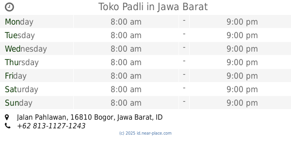
Toko Padli
Jalan Pahlawan, Sentul
Convenience store
read more
964 m
Depot Air Mas
JL Sirkuit Sentul, RT 4 RW 1, Sentul
Convenience store
read more
976 m
Toko Zaenal
Jalan Raya Sirkuit Sentul, Sentul
Convenience store
read more
1.008 km
Alfamart Tatya Asri
Jalan Tatya Hanem 3 No.20, Cijujung
Convenience store
read more
1.017 km
Indomaret
Jalan Alternatif Sentul No.5 C, Cijujung
Convenience store
read more
1.034 km
Alfamart Sirkuit Sentul
Jalan Raya Sirkuit Sentul No.69, Sentul, Babakan Madang, Sentul
Convenience store
read more
1.164 km
Sap Water
Jalan Raya Sirkuit Sentul No.8, Kadumangu
Convenience store
read more
1.218 km
Toko Dino
Jalan Pahlawan, Sentul
Convenience store
read more
1.543 km
Toko Fauzi
Jalan Raya Bogor, Cimandala
Convenience store
read more
1.565 km
Indomaret KM 48
Jalan Raya Bogor, Nanggewer
Convenience store
read more
1.646 km
Alfamidi Cibinong KM 48
Jalan Raya Bogor KM 48, Nanggewer Mekar, Cibinong, Nanggewer
Convenience store
read more
1.898 km
Toko Salsa
Jalan Bintang Mas, Nanggewer
Convenience store
read more
1.963 km
Toko Amanah
Jalan Raya Bogor, Nanggewer Mekar
Convenience store
read more
2.01 km
Four D
Jalan Raya Sirkuit Sentul No.55, Leuwinutug
Convenience store
read more
2.137 km
Toko Ibu Wanti
Jalan Pahlawan, Leuwinutug
Convenience store
read more
2.351 km
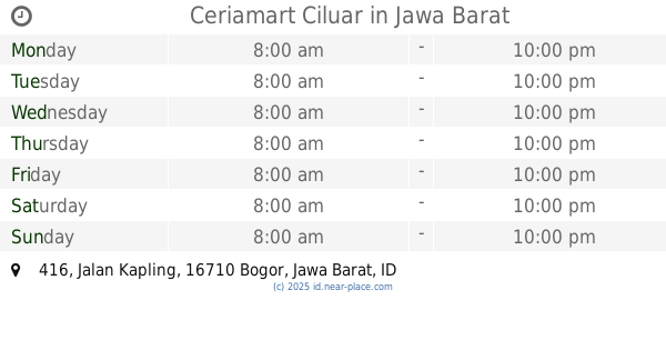
Ceriamart Ciluar
Jalan Kapling No.416, Cijujung
Convenience store
read more
2.618 km
Toko Ida
Jalan Pahlawan, Sanja
Convenience store
read more
📑
all categories
Accounting
Administrative area level 1
Administrative area level 2
Airport
Amusement park
Aquarium
Art gallery
Atm
Bakery
Bank
Bar
Beauty salon
Bicycle store
Book store
Bowling alley
Bus station
Cafe
Campground
Car dealer
Car rental
Car repair
Car wash
Casino
Cemetery
Church
City hall
Clothing store
Colloquial area
Convenience store
Courthouse
Dentist
Department store
Doctor
Electrician
Electronics store
Embassy
Finance
Fire station
Florist
Food
Funeral home
Furniture store
Gas station
General contractor
Grocery or supermarket
Gym
Hair care
Hardware store
Health
Hindu Temple
Home goods store
Hospital
Insurance agency
Intersection
Jewelry store
Laundry
Lawyer
Library
Liquor store
Local government office
Locality
Locksmith
Lodging
Meal delivery
Meal takeaway
Mosque
Movie rental
Movie theater
Moving company
Museum
Natural feature
Neighborhood
Night club
Painter
Park
Parking
Pet store
Pharmacy
Physiotherapist
Place of worship
Plumber
Point of interest
Police
Political
Post office
Premise
Real estate agency
Restaurant
Roofing contractor
Route
Rv park, camping
School
Shoe store
Shopping mall
Spa
Stadium
Storage
Store
Subpremise
Supermarket
Synagogue
Taxi stand
Train station
Transit station
Travel agency
University
Veterinary care
Zoo
administrative area level 3
administrative area level 4
administrative area level 5
sublocality level 1
↑