
no info
🕗 opening times
| Monday | ⚠ | |||||
| Tuesday | ⚠ | |||||
| Wednesday | ⚠ | |||||
| Thursday | ⚠ | |||||
| Friday | ⚠ | |||||
| Saturday | ⚠ | |||||
| Sunday | ⚠ | |||||
JL. May. Jend. Sutoyo, Cawang, 13630 Jakarta Timur, Indonesia, Cawang, Kramatjati, Kota Jakarta Timur, Daerah Khusus Ibukota Jakarta, Indonesia
contacts phone: +62
larger map & directionsLatitude: -6.2503526, Longitude: 106.8735954
Adi Setiya
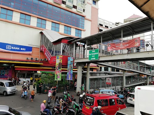
::Take a look at this Pict, and this happen almost all the time here, except 0 am and holidays. Too many cross section, too many busses, ojeks, cars and some other etc. This interchange area always be like that. CA can Can not imagine how jakartans live like this everyday and trough this road.
Esa Dicky
::Sampah chaos parah. If you want to go here (or this area) I recommended you to use online transportation such as Grab Bike or Go-Ride by Gojek. Unless you are ready to get stuck for hours.
Erry Deodata
::Crowded during rush hours, and my name is captain obvious. Routes being served are: PGC Ancol Tanjung Priok Grogol Kampung Melayu Kampung Rambutan Harmoni Cibubur Junction Depok
A Glenn
::This is one of transit shelter of Transjakarta. This shelter is adjacent to Universitas Kristen Indonesia, makes this place really important for citizen of UKI that want to go to several places in entire of Jakarta. The place is easily accessible.
Kay Nazarite
::This is a great transit shelter. Not too big so people can switch/transit TJ easily & not walking so far.