Cafe nearby YR Mart & Travel
Indonesia
Cafe nearby YR Mart & Travel
YR Mart & Travel
Kamonji Indonesia
contacts phone
:
+62
Latitude:
-0.8976564
, Longitude:
119.8550308
read more
nearest Cafe
48 m
Bintehasrat
Jalan Datu Pamusu, Kamonji
Cafe
read more
135 m
Kedai The Kamondji
Kamonji
Cafe
read more
351 m
RM DAN CAFE ANDRES
Jalan Imam Bonjol No.288, Baru
Cafe
read more
384 m
Ngopi Di Palu
Jalan Imam Bonjol, Siranindi
Cafe
read more
397 m
Es Teler Bandung
Jalan Imam Bonjol, Baru
Cafe
read more
455 m
Cafe Abil
Jalan H Agus Salim, Siranindi
Cafe
read more
470 m
Shop Black and White
Jalan Belimbing, Kamonji
Cafe
read more
481 m
Palbar Cafe & Co
Siranindi
Cafe
read more
508 m
Kafe binte
Baru
Cafe
read more
518 m
Cafe Intel
Jl. Wahid Hasyim, Baru
Cafe
read more
539 m
WARUNG MAKAN TOLEDO
Jalan Sis Aljufri, Siranindi
Cafe
read more
544 m
Glass N' Spoon | Kebabs & Drinks
Jl. Sis Aljufri, Kel. Siranindi, Kec. Palu-barat, PO.BOX 94111 Kompleks ruko/pertokoan Al-Khairaat, Siranindi
Cafe
read more
568 m
D'Warunk
Jalan Kyai Haji Wahid Hasyim No.52, Baru
Cafe
read more
569 m
warung tar'im
Jalan Sis Aljufri, Siranindi
Cafe
read more
579 m
Bakso Tenis
Siranindi
Cafe
read more
616 m
warung zakia (Indonesian kuliner)
Jalan HOS Cokroaminoto, Baru
Cafe
read more
634 m
Manna Bakery
Jalan Gajah Mada, Siranindi
Cafe
read more
651 m
Bubuk Minuman Palu
Siranindi
Cafe
read more
685 m
Warkop Harapan Indah
Jalan Danau Lindu No. 2, Siranindi, Palu Barat, Siranindi
Cafe
read more
717 m
Kios SURYA BANJAR
Jalan Teuku Umar No.80, Baru
Cafe
read more
881 m
Pisang Pasir
Lere
Cafe
read more
885 m
Pisang Pasir AA
Jalan Tanjung Bulu, Lere
Cafe
read more
1.04 km
Cuci Motor Salju Lampu 10
Ujuna
Cafe
read more
1.069 km
Kedai "Bean The Kitty"
Jalan Rajamoili No.33, Besusu Barat
Cafe
read more
1.12 km
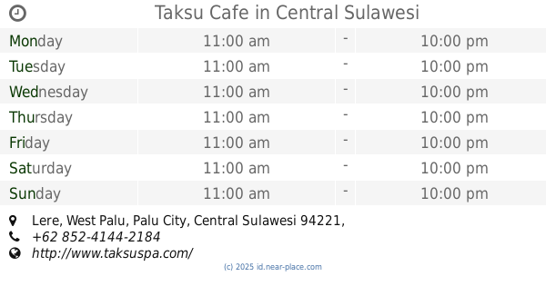
Taksu Cafe
Lere
Cafe
read more
📑
all categories
Accounting
Administrative area level 1
Administrative area level 2
Airport
Amusement park
Aquarium
Art gallery
Atm
Bakery
Bank
Bar
Beauty salon
Bicycle store
Book store
Bowling alley
Bus station
Cafe
Campground
Car dealer
Car rental
Car repair
Car wash
Casino
Cemetery
Church
City hall
Clothing store
Colloquial area
Convenience store
Courthouse
Dentist
Department store
Doctor
Electrician
Electronics store
Embassy
Finance
Fire station
Florist
Food
Funeral home
Furniture store
Gas station
General contractor
Grocery or supermarket
Gym
Hair care
Hardware store
Health
Hindu Temple
Home goods store
Hospital
Insurance agency
Intersection
Jewelry store
Laundry
Lawyer
Library
Liquor store
Local government office
Locality
Locksmith
Lodging
Meal delivery
Meal takeaway
Mosque
Movie rental
Movie theater
Moving company
Museum
Natural feature
Neighborhood
Night club
Painter
Park
Parking
Pet store
Pharmacy
Physiotherapist
Place of worship
Plumber
Point of interest
Police
Political
Post office
Premise
Real estate agency
Restaurant
Roofing contractor
Route
Rv park, camping
School
Shoe store
Shopping mall
Spa
Stadium
Storage
Store
Subpremise
Supermarket
Synagogue
Taxi stand
Train station
Transit station
Travel agency
University
Veterinary care
Zoo
administrative area level 3
administrative area level 4
administrative area level 5
sublocality level 1
↑