Cafe nearby Weeskind Market
Coronavirus disease (COVID-19) Situation
confirmed cases
6829221
deaths
162063
Indonesia
Cafe nearby Weeskind Market
Weeskind Market
Jl. Juanda No. 65 palu, Lolu Utara Indonesia
contacts phone
:
+62
Latitude:
-0.8970357
, Longitude:
119.8844665
read more
nearest Cafe
241 m
BaseCampCoffee
Jalan G. Sidole, Lolu Utara
Cafe
read more
361 m
Tanaris Coffee
Jalan Juanda No.26, Lolu Utara
Cafe
read more
461 m
Monin Palu
North Lolu
Cafe
read more
590 m
JOIN COFFEE PALU
South Lolu
Cafe
read more
597 m
Natuvu Net
Jalan R.A. Kartini, Palu Selatan, Lolu Selatan
Cafe
read more
616 m
Caffe Wl
Jalan Tanjung Malakosa, Lolu Selatan
Cafe
read more
683 m
Mrs. Cupi - Cumi Krispi
Jalan Balaikota, Tanamodindi
Cafe
read more
775 m
Cafe 168 House
Jalan Setia Budi, Besusu Tengah
Cafe
read more
783 m
Kue Bosa V
Jalan Gunung Bosa No.14, Lolu Utara
Cafe
read more
789 m
Mas leo siomay maknyus
Jalan Balai Kota Selatan, Tanamodindi
Cafe
read more
791 m
Mas leo
Jalan Balai Kota Selatan, Tanamodindi
Cafe
read more
794 m
Warkop Hanbae
Jalan Tanjung Dako, Lolu Selatan
Cafe
read more
804 m
Warkop Kpk Daeng Maman
Jalan Walikota, Entrop
Cafe
read more
804 m
Roti Comel
Jalan Walikota, Tanamodindi
Cafe
read more
805 m
pantoloanCONFIRM
North Lolu
Cafe
read more
805 m
Andika
Palu
Cafe
read more
807 m
Warung Makan Nang Jaya
Besusu Tengah
Cafe
read more
824 m
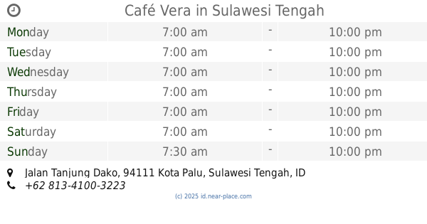
Café Vera
Jalan Tanjung Dako, Lolu Selatan
Cafe
read more
891 m
Garasi Kopi Sutomo
Jalan Dokter Soetomo No.11, Besusu Tengah
Cafe
read more
908 m
Rutenitas39
Jalan Tadulako, Besusu Tengah
Cafe
read more
950 m
Warkop Sikamali 3 Moh Hatta
Jalan. Dokter Drs. Haji Muhammad Hatta No.55, Lolu Utara
Cafe
read more
1.029 km
Nasi Kuning Ningrat 5010
Lorong Kosgoro No.18A, Lolu Selatan
Cafe
read more
1.063 km
Roemah El's
102-96, Jalan Tanjung Satu, Tatura Utara
Cafe
read more
1.143 km
Dum Dum Thai Drinks BNS S.Parman
Bumi Nyiur Swalayan (Foodcourt, Besusu Tengah
Cafe
read more
1.16 km
Warkop Roemah Rakyat
South Lolu
Cafe
read more
📑
all categories
Accounting
Administrative area level 1
Administrative area level 2
Airport
Amusement park
Aquarium
Art gallery
Atm
Bakery
Bank
Bar
Beauty salon
Bicycle store
Book store
Bowling alley
Bus station
Cafe
Campground
Car dealer
Car rental
Car repair
Car wash
Casino
Cemetery
Church
City hall
Clothing store
Colloquial area
Convenience store
Courthouse
Dentist
Department store
Doctor
Electrician
Electronics store
Embassy
Finance
Fire station
Florist
Food
Funeral home
Furniture store
Gas station
General contractor
Grocery or supermarket
Gym
Hair care
Hardware store
Health
Hindu Temple
Home goods store
Hospital
Insurance agency
Intersection
Jewelry store
Laundry
Lawyer
Library
Liquor store
Local government office
Locality
Locksmith
Lodging
Meal delivery
Meal takeaway
Mosque
Movie rental
Movie theater
Moving company
Museum
Natural feature
Neighborhood
Night club
Painter
Park
Parking
Pet store
Pharmacy
Physiotherapist
Place of worship
Plumber
Point of interest
Police
Political
Post office
Premise
Real estate agency
Restaurant
Roofing contractor
Route
Rv park, camping
School
Shoe store
Shopping mall
Spa
Stadium
Storage
Store
Subpremise
Supermarket
Synagogue
Taxi stand
Train station
Transit station
Travel agency
University
Veterinary care
Zoo
administrative area level 3
administrative area level 4
administrative area level 5
sublocality level 1
↑