Cafe nearby Warkop TORAYAKU
Coronavirus disease (COVID-19) Situation
confirmed cases
6829221
deaths
162063
Indonesia
Cafe nearby Warkop TORAYAKU
Warkop TORAYAKU
Bar., Lere Indonesia
contacts phone
:
+62
Latitude:
-0.8845069
, Longitude:
119.8532899
read more
nearest Cafe
47 m
Cafe Roti Gaul (Taman Ria)
Jalan Cumi-Cumi, Lere
Cafe
read more
221 m
Smart Avenue Palu
Jalan Cumi-Cumi, Lere
Cafe
read more
405 m
Excelso
Jl.Cumi-Cumi No. 10 (Taman Ria) , Ground Floor Palu, Lere
Cafe
read more
542 m
Pantai Talise
Jalan Cumi-Cumi, Lere
Cafe
read more
561 m
Dange Jajanan Palu
Bar., Lere
Cafe
read more
605 m
Cafe Rasfren
Jalan Cumi-Cumi, Lere
Cafe
read more
611 m
Aditama Café
No.7, Jl. Abd. Raqie Glr. Datokarama, Lere
Cafe
read more
669 m
Kafe Global
Jalan Cumi-Cumi No.16, Lere
Cafe
read more
690 m
Warkop De'Ofis
Lere
Cafe
read more
725 m
Calais Cafe Palu
Jalan Diponegoro, Lere
Cafe
read more
747 m
Pisang Pasir AA
Jalan Tanjung Bulu, Lere
Cafe
read more
747 m
Warkop Fekon Unisa Palu
Jalan Tanjung Bulu, Lere
Cafe
read more
752 m
Pisang Pasir
Lere
Cafe
read more
759 m
Cafe Idola
Jalan Cumi-Cumi, Lere
Cafe
read more
800 m
Roti Bakar "Paris van Java" - Diponegoro
Jalan Diponegoro, Lere
Cafe
read more
859 m
Lapangan Futsal Rajamoili 'n' Smile Cafe
Jalan Raden Saleh No.29a, Besusu Barat
Cafe
read more
862 m
ES DUREN
Lere
Cafe
read more
882 m
Smile Cafe
Jalan Rajamoili, Besusu Barat
Cafe
read more
942 m
Kedai_dhal
Jalan Diponegoro, Lere
Cafe
read more
950 m
Cafe Blackgreen
bantiln, Jalan Bantilan, Lere
Cafe
read more
967 m
Kafe binte
Baru
Cafe
read more
969 m
Binte hasrat
Baru
Cafe
read more
1.027 km
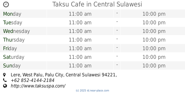
Taksu Cafe
Lere
Cafe
read more
1.121 km
D'Warunk
Jalan Kyai Haji Wahid Hasyim No.52, Baru
Cafe
read more
1.167 km
Kedai "Bean The Kitty"
Jalan Rajamoili No.33, Besusu Barat
Cafe
read more
📑
all categories
Accounting
Administrative area level 1
Administrative area level 2
Airport
Amusement park
Aquarium
Art gallery
Atm
Bakery
Bank
Bar
Beauty salon
Bicycle store
Book store
Bowling alley
Bus station
Cafe
Campground
Car dealer
Car rental
Car repair
Car wash
Casino
Cemetery
Church
City hall
Clothing store
Colloquial area
Convenience store
Courthouse
Dentist
Department store
Doctor
Electrician
Electronics store
Embassy
Finance
Fire station
Florist
Food
Funeral home
Furniture store
Gas station
General contractor
Grocery or supermarket
Gym
Hair care
Hardware store
Health
Hindu Temple
Home goods store
Hospital
Insurance agency
Intersection
Jewelry store
Laundry
Lawyer
Library
Liquor store
Local government office
Locality
Locksmith
Lodging
Meal delivery
Meal takeaway
Mosque
Movie rental
Movie theater
Moving company
Museum
Natural feature
Neighborhood
Night club
Painter
Park
Parking
Pet store
Pharmacy
Physiotherapist
Place of worship
Plumber
Point of interest
Police
Political
Post office
Premise
Real estate agency
Restaurant
Roofing contractor
Route
Rv park, camping
School
Shoe store
Shopping mall
Spa
Stadium
Storage
Store
Subpremise
Supermarket
Synagogue
Taxi stand
Train station
Transit station
Travel agency
University
Veterinary care
Zoo
administrative area level 3
administrative area level 4
administrative area level 5
sublocality level 1
↑