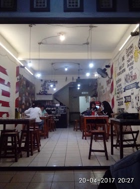
Cafe nearby Warduk Buluk Family Bersatu
Indonesia
Cafe nearby Warduk Buluk Family Bersatu
Warduk Buluk Family Bersatu
Jalan Raya Salembaran Gang Telkom, Salembaran Indonesia
contacts phone
:
+62
Latitude:
-6.0754457
, Longitude:
106.6620901
read more
nearest Cafe
177 m
M. Zohan Sanca Manggala
Jalan Melati, Salembaran
Cafe
read more
238 m
Djogja Ngangkring's
Salembaran
Cafe
read more
292 m
Nasi Uduk Ene
Jalan Radio Pantura, Salembaran
Cafe
read more
312 m
es kelapa muda bu noy
Unnamed Road, Salembaran
Cafe
read more
377 m
Martabak Tegal Laka-laka
Jalan Raya Salembaran No.38, Salembaran
Cafe
read more
420 m
WARUNG ES POP ES POK NUNG
Salembaran, Kosambi, Salembaran
Cafe
read more
426 m
Warung Jus & Seblak Ibu Titin
Jalan Raya Salembaran, Kosambi Barat
Cafe
read more
428 m
Warung Pop Es Pok Nung
Salembaran, Kosambi, Salembaran
Cafe
read more
431 m
Warung Pop Es Bunda NUNG
Salembaran, Kosambi, Salembaran
Cafe
read more
513 m
Dapur Danisa
Jalan Cendana V No.54, Salembaran
Cafe
read more
528 m
Warung Bude
Unnamed Road, Salembaran
Cafe
read more
568 m
Warkop Bang Hendra
Jalan Putri, Salembaran
Cafe
read more
585 m
Seblak Khas Bandung - Seblak Ceker
no., Jalan Raya Salembaran RT.5, Kampung Melayu Timur
Cafe
read more
585 m
Rental Ps Ramuel
Salembaran
Cafe
read more
593 m
Cafe Kaplink
Unnamed Road, Salembaran
Cafe
read more
599 m
Cafe putri5
Salembaran
Cafe
read more
603 m
Cafe Emen
Jalan Putri, Salembaran
Cafe
read more
617 m
Rental PS Bimo New
Salembaran
Cafe
read more
632 m
KantinQu AL-Saidah
Unnamed Road, Babakan Asem
Cafe
read more
667 m
Mess Rekind
Puri Naga Indah blok A3/2, Kampung Melayu Timur
Cafe
read more
745 m
Warung Kopi Naga
East Kampung Melayu
Cafe
read more
834 m
Cafe Capucino Cincau
Jalan Farikha No.1, Salembaran
Cafe
read more
918 m
fairush cafe
East Kampung Melayu
Cafe
read more
926 m
Noah Cafe
Jalan Raya Salembaran No.7, Kampung Melayu Timur
Cafe
read more
961 m
Gerai Alkarob
Jalan Kedung Raya, Babakan Asem
Cafe
read more
📑
all categories
Accounting
Administrative area level 1
Administrative area level 2
Airport
Amusement park
Aquarium
Art gallery
Atm
Bakery
Bank
Bar
Beauty salon
Bicycle store
Book store
Bowling alley
Bus station
Cafe
Campground
Car dealer
Car rental
Car repair
Car wash
Casino
Cemetery
Church
City hall
Clothing store
Colloquial area
Convenience store
Courthouse
Dentist
Department store
Doctor
Electrician
Electronics store
Embassy
Finance
Fire station
Florist
Food
Funeral home
Furniture store
Gas station
General contractor
Grocery or supermarket
Gym
Hair care
Hardware store
Health
Hindu Temple
Home goods store
Hospital
Insurance agency
Intersection
Jewelry store
Laundry
Lawyer
Library
Liquor store
Local government office
Locality
Locksmith
Lodging
Meal delivery
Meal takeaway
Mosque
Movie rental
Movie theater
Moving company
Museum
Natural feature
Neighborhood
Night club
Painter
Park
Parking
Pet store
Pharmacy
Physiotherapist
Place of worship
Plumber
Point of interest
Police
Political
Post office
Premise
Real estate agency
Restaurant
Roofing contractor
Route
Rv park, camping
School
Shoe store
Shopping mall
Spa
Stadium
Storage
Store
Subpremise
Supermarket
Synagogue
Taxi stand
Train station
Transit station
Travel agency
University
Veterinary care
Zoo
administrative area level 3
administrative area level 4
administrative area level 5
sublocality level 1
↑