Cafe nearby Es KLAPA GUBUK TEKO
Coronavirus disease (COVID-19) Situation
confirmed cases
6829221
deaths
162063
Indonesia
Cafe nearby Es KLAPA GUBUK TEKO
Es KLAPA GUBUK TEKO
Citayam Indonesien
contacts phone
:
+62
Latitude:
-6.4419934
, Longitude:
106.7424442
read more
nearest Cafe
126 m
Es Kelapa GUBUK TEKO
Unnamed Road, Citayam
Cafe
read more
155 m
De'gan (Es Kelapa Muda)
ragamukti no 54, Citayam
Cafe
read more
158 m
Es Kelapa Degan
Citayam
Cafe
read more
216 m
Pie dan kue Soes " Minnie "
Kencana Asri 3, Blok B No.14 RT 001/RW 003. kampung Raga Mukti, 16320, Citayam
Cafe
read more
252 m
Cowzy Fresh Milk Arco
Citayam
Cafe
read more
256 m
COWZY Fresh Milk and Es Kepal
Citayam
Cafe
read more
352 m
Nasi Goreng Babe
Jalan Arco Raya No.23, Citayam
Cafe
read more
410 m
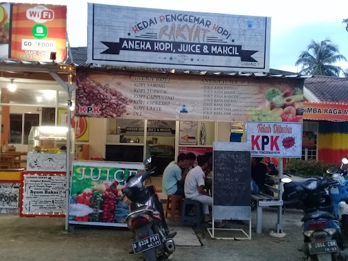
Kedai Penggemar Kopi (KPK)
Jalan Arco Raya No.B.20, Raga mukti
Cafe
read more
552 m
Banana Nugget By Dian Ang
Jalan Arco Raya, Duren Seribu
Cafe
read more
656 m
Bubur Ayam Cianjur
Jalan Arco Raya No.27, Citayam
Cafe
read more
657 m
Mie Ayam & Bakso
Jalan Arco Raya No.27, Citayam
Cafe
read more
733 m
ES TELER ADEL
Jalan Duren Seribu, Duren Seribu
Cafe
read more
797 m
Cafe Papua
jl papua lebak wanggi, Parung
Cafe
read more
798 m
cafe kiuk
Unnamed Road, Parung
Cafe
read more
820 m
Explode Food House
Jalan Jambu, Duren Seribu
Cafe
read more
850 m
Warung Kopi Mak Encim
Duren Seribu
Cafe
read more
960 m
Bubur Ayam"SEHAT'i"pak.Endang.
Jl. Tengah komplk.Pondok Mutiara No.depan, Sasak Panjang
Cafe
read more
1.003 km
🚴 GBHM
Jalan Raya Parung No.420, Pemagarsari
Cafe
read more
1.022 km
Cafe Ze
Pemagarsari
Cafe
read more
1.022 km
Cafe Ze
Indonesia
Cafe
read more
1.027 km
Cafe Nongkrong Parung
Jalan Jakarta - Bogor No.194, Parung
Cafe
read more
1.042 km
Warung Soto A12 Pondok Mutiara
Sasak Panjang
Cafe
read more
1.101 km
Teras Parung
Jalan Raya Parung No.03, Parung
Cafe
read more
1.115 km
Nyoklat Super
Jalan Arco Raya, Kalisuren
Cafe
read more
1.196 km
Kedai 45
Jalan Arco Raya No.118, Kalisuren
Cafe
read more
📑
all categories
Accounting
Administrative area level 1
Administrative area level 2
Airport
Amusement park
Aquarium
Art gallery
Atm
Bakery
Bank
Bar
Beauty salon
Bicycle store
Book store
Bowling alley
Bus station
Cafe
Campground
Car dealer
Car rental
Car repair
Car wash
Casino
Cemetery
Church
City hall
Clothing store
Colloquial area
Convenience store
Courthouse
Dentist
Department store
Doctor
Electrician
Electronics store
Embassy
Finance
Fire station
Florist
Food
Funeral home
Furniture store
Gas station
General contractor
Grocery or supermarket
Gym
Hair care
Hardware store
Health
Hindu Temple
Home goods store
Hospital
Insurance agency
Intersection
Jewelry store
Laundry
Lawyer
Library
Liquor store
Local government office
Locality
Locksmith
Lodging
Meal delivery
Meal takeaway
Mosque
Movie rental
Movie theater
Moving company
Museum
Natural feature
Neighborhood
Night club
Painter
Park
Parking
Pet store
Pharmacy
Physiotherapist
Place of worship
Plumber
Point of interest
Police
Political
Post office
Premise
Real estate agency
Restaurant
Roofing contractor
Route
Rv park, camping
School
Shoe store
Shopping mall
Spa
Stadium
Storage
Store
Subpremise
Supermarket
Synagogue
Taxi stand
Train station
Transit station
Travel agency
University
Veterinary care
Zoo
administrative area level 3
administrative area level 4
administrative area level 5
sublocality level 1
↑