Bar nearby Warung Coconut & coffee
Coronavirus disease (COVID-19) Situation
confirmed cases
6829221
deaths
162063
Indonesia
Bar nearby Warung Coconut & coffee
Warung Coconut & coffee
no 16154, Jalan Raya Tanah Baru Blok B No.1, 8, Tanah Baru Indonesien
contacts phone
:
+62
Latitude:
-6.5802315
, Longitude:
106.8216864
read more
nearest Bar
478 m
Milk Bar Cafe
Tegal Gundil
Bar
read more
490 m
WBS Farmasi Bogor
Cimahpar
Bar
read more
549 m
BaleG Coffee Roastery
Jalan Drupada VI No.4, Tegal Gundil
Bar
read more
1.039 km
Achmad Sobana11
Jalan Achmad Sobana, Tegal Gundil
Bar
read more
1.179 km
Duta Jaya HQ
Jalan Gagalur I, Tegal Gundil
Bar
read more
1.199 km
ES KELAPA MANG WENDI
Jalan Bangbarung Raya, Tegal Gundil
Bar
read more
1.248 km
Vin Plus
Bantarjati
Bar
read more
1.588 km
SMK BINA PROFESI BOGOR
Bantarjati, Bogor Utara, Bantarjati
Bar
read more
1.589 km
CAFE IWAN
Jl. Nasional No.11, Bantarjati
Bar
read more
1.702 km
warung teteh warkop bilqis
Jalan Lodaya II No.3, Babakan
Bar
read more
1.802 km
RFS
16151, Jalan Pajajaran/Komp. Peternakan No.48, Cibuluh
Bar
read more
1.848 km
RHS
Jl. Komp. No.54, Cibuluh
Bar
read more
2.021 km
Billyar Pangrango
Babakan
Bar
read more
2.054 km
blackseed coffee
No.,, Jalan Sancang No.9, Babakan
Bar
read more
2.075 km
bars soka & musik
Sukaraja
Bar
read more
2.178 km
Warung Ibu
Jalan Tegallega, Tegallega
Bar
read more
2.194 km
Complex STREET
Jalan Raya Pajajaran Blok Dahlia No.21, Cibuluh
Bar
read more
2.24 km
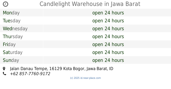
Candlelight Warehouse
jalan, Tegallega
Bar
read more
2.269 km
Candlelight Warehouse
Jalan Danau Tempe, Tegallega
Bar
read more
2.278 km
POKET BILIARD HADY
Kampung Parung Jambu, Babakan
Bar
read more
2.357 km
Mosquito Bar & Lounge
Babakan
Bar
read more
2.402 km
Jz Caffe And Poolbar
no 6, Jalan Dadali No.3, Tanah Sareal
Bar
read more
2.6 km
Asep
Kedung Badak
Bar
read more
3.708 km
TestBroBogor
Jalan Surya Kencana No.146, Babakan Pasar
Bar
read more
3.833 km
Es Kelapa Safari
Jalan Kampung Cincau No.36-22, Gudang
Bar
read more
📑
all categories
Accounting
Administrative area level 1
Administrative area level 2
Airport
Amusement park
Aquarium
Art gallery
Atm
Bakery
Bank
Bar
Beauty salon
Bicycle store
Book store
Bowling alley
Bus station
Cafe
Campground
Car dealer
Car rental
Car repair
Car wash
Casino
Cemetery
Church
City hall
Clothing store
Colloquial area
Convenience store
Courthouse
Dentist
Department store
Doctor
Electrician
Electronics store
Embassy
Finance
Fire station
Florist
Food
Funeral home
Furniture store
Gas station
General contractor
Grocery or supermarket
Gym
Hair care
Hardware store
Health
Hindu Temple
Home goods store
Hospital
Insurance agency
Intersection
Jewelry store
Laundry
Lawyer
Library
Liquor store
Local government office
Locality
Locksmith
Lodging
Meal delivery
Meal takeaway
Mosque
Movie rental
Movie theater
Moving company
Museum
Natural feature
Neighborhood
Night club
Painter
Park
Parking
Pet store
Pharmacy
Physiotherapist
Place of worship
Plumber
Point of interest
Police
Political
Post office
Premise
Real estate agency
Restaurant
Roofing contractor
Route
Rv park, camping
School
Shoe store
Shopping mall
Spa
Stadium
Storage
Store
Subpremise
Supermarket
Synagogue
Taxi stand
Train station
Transit station
Travel agency
University
Veterinary care
Zoo
administrative area level 3
administrative area level 4
administrative area level 5
sublocality level 1
↑